Karmactive Team
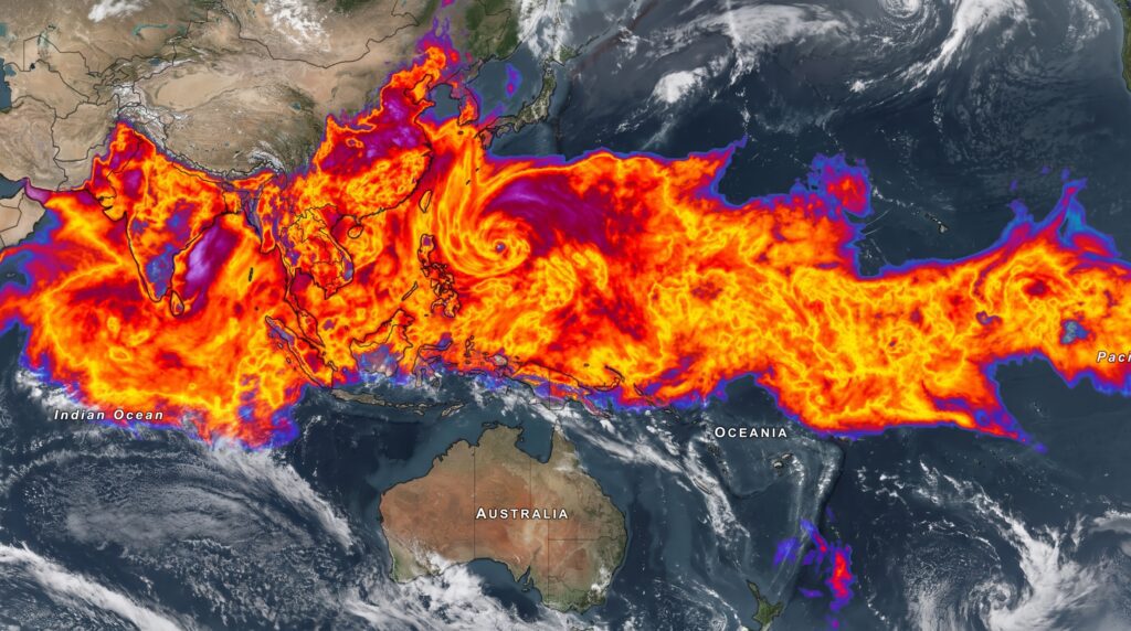
A 10,000-kilometre monsoon rain cloud stretching from India to South Korea has been captured in satellite imagery, marking one of the most expansive cloud formations seen this season over South and East Asia.
ISRO’s satellite imagery revealed a near-continuous cloud mass running from the Arabian Sea and Bay of Bengal, across Myanmar, through the Korean Peninsula, reaching South Korea. India’s Meteorological Department confirmed the system is linked to an active monsoon trough positioned along the Indo-Gangetic plains. Such troughs are a normal feature of the Indian monsoon, but a system of this spatial scale is not routine.
India’s monsoon season depends on moisture-laden southwest winds from the Arabian Sea. When a monsoon trough strengthens and stretches this far, it signals that the atmospheric moisture supply feeding the system is particularly robust. Forecasters tracking the formation noted it coincided with above-normal ocean temperatures in the Bay of Bengal, which amplifies convective activity and cloud formation.
For farmers across Bihar, Uttar Pradesh, West Bengal, and Assam — all in the direct path of the system — the rainfall arriving from this trough is critical. India’s monsoon delivers roughly 70 percent of the country’s annual precipitation. When the trough is active and well-placed, districts that ordinarily struggle with patchy rainfall can receive a season’s worth within a few days.
South Korea’s weather agencies noted increased cloud cover and rainfall associated with the system’s outer circulation. The Korean Peninsula lies at the northern fringe of the East Asian monsoon, which occasionally interacts with Indian monsoon circulation during particularly active periods.
The 10,000-km cloud formation became widely visible through ISRO satellite images shared by meteorological agencies. Modern geostationary satellite systems allow near-real-time tracking of cloud formations, enabling weather agencies to issue alerts days in advance rather than hours.
For flood-prone communities, particularly in low-lying zones across eastern India, the system brings practical risks alongside agricultural benefits. Monsoon surges of this scale test urban drainage systems not designed for the volumes of rain that large sustained troughs can deliver. The IMD issued heavy rainfall warnings for multiple states, urging residents in flagged districts to monitor local advisories and avoid flood-prone areas during peak rainfall windows.
India has recorded several large-scale monsoon events in recent decades. The 2005 Mumbai floods, 2013 Kedarnath disaster, and 2019 Kerala floods all involved sustained large moisture-laden systems. The difference today is early satellite-based detection that gives authorities days rather than hours to respond.
Monsoon-related deaths remain a persistent concern across northern India. Residents in IMD-flagged districts should stay connected to official weather updates, avoid waterlogged roads, and follow district administration advisories as the system continues tracking across the region.