Sonali Tiwary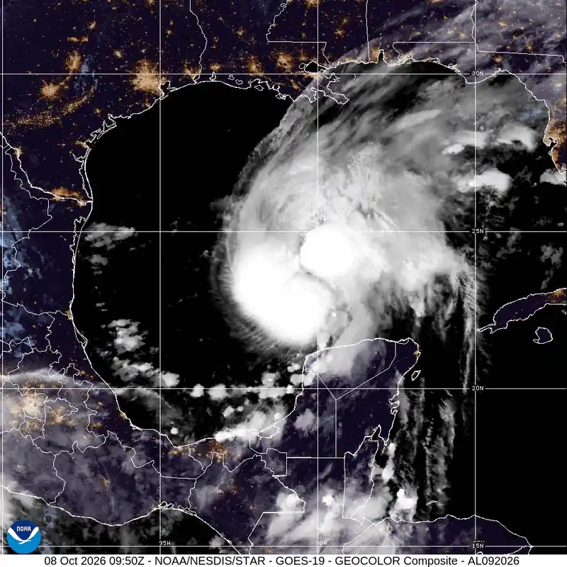
Tropical Storm Isaias has been officially named and federal watches are now in effect along the northern Gulf Coast. Since the Gulf disturbance organized into Tropical Depression Nine on October 6 and was named Isaias on October 7, the system has strengthened rapidly, with hurricane, tropical-storm, and storm-surge watches now covering portions of the northern Gulf Coast — and the time to prepare is shrinking faster than the track forecast suggests.
By 4 p.m. CDT October 7, the National Hurricane Center reported Isaias had strengthened to maximum sustained winds of 65 mph with a central pressure of 994 mb, moving east-northeast at 8 mph. NHC has issued a Hurricane Watch from Bay St. Louis, Mississippi, to Indian Pass, Florida, a Storm Surge Watch from the mouth of the Mississippi River to Yankeetown, Florida, and Tropical Storm Watches on either side of those areas. Landfall is forecast for late Friday or early Saturday, most likely between Biloxi, Mississippi, and Panama City Beach, Florida, with NHC projecting a Category 2 hurricane at landfall. Florida Governor Ron DeSantis has signed Executive Order 26-202, placing 25 northern and Gulf Coast counties under emergency declaration.
Your preparation window does not end at landfall — it ends before Friday. Tropical-storm-force winds from Isaias extended up to 60 miles from the center as of the October 7 evening advisory, with the wind field expected to expand as the storm strengthens. Tropical-storm conditions could begin in portions of the watch area before landfall on Friday, making outdoor preparations increasingly difficult or dangerous. Strong winds can prompt local authorities to restrict or close vulnerable bridges and causeways. Secure outdoor structures, top off generators with fuel, and check your county’s evacuation zone status through your local emergency management office today.
What the Watch Area Actually Covers
A tropical storm watch means tropical-storm conditions are possible within the specified watch area, generally within 48 hours — not guaranteed along the forecast center line. NHC’s watch geography extends well beyond the cone. People living in the watch area face real exposure regardless of whether the storm’s center passes directly over them. A social-media track graphic and the official watch area are not the same thing; decisions should come from the NHC advisory, not a shared image.
NHC described Isaias as developing over very warm sea-surface temperatures and in a very humid environment. NHC reported that Isaias was temporarily benefiting from low to moderate shear, although stronger shear was expected near landfall. NHC is projecting a Category 2 hurricane at landfall.
NHC has also warned of a dangerous storm surge of 5 to 7 feet above ground level from Ocean Springs, Mississippi, to Indian Pass, Florida, if the peak surge aligns with high tide. Rainfall of 3 to 7 inches is forecast across the watch area, with localized totals up to 10 inches possible.
Florida’s Executive Order 26-202 declares a state of emergency and allows the Florida Division of Emergency Management to stage preparedness resources and respond to the storm. The order covers Baker, Bay, Calhoun, Columbia, Dixie, Escambia, Franklin, Gadsden, Gilchrist, Gulf, Hamilton, Holmes, Jackson, Jefferson, Lafayette, Leon, Liberty, Madison, Okaloosa, Santa Rosa, Suwannee, Taylor, Walton, Wakulla, and Washington counties — 25 in total, spanning the Panhandle and Big Bend regions. Residents in those areas can also access FEMA disaster preparation resources and local NWS office forecasts specific to their county.
What areas are under a watch for Isaias?
NHC has issued a Hurricane Watch from Bay St. Louis, Mississippi, to Indian Pass, Florida, a Storm Surge Watch from the mouth of the Mississippi River to Yankeetown, Florida, and Tropical Storm Watches on either side of those areas. Florida’s 25-county emergency declaration covers the Panhandle and Big Bend counties listed above. Residents in Mississippi and Alabama should check local emergency management offices for current watch or warning status, as NHC advisories are updated regularly and conditions can change between updates.
Check the latest NHC advisory before making any preparation decisions — storm-track graphics shared on social media frequently lag official advisories.
NHC is issuing updated advisories as Isaias approaches the coast. The next advisory will confirm whether the storm has intensified further. Check back for updated storm surge totals and any changes to evacuation orders as landfall approaches.