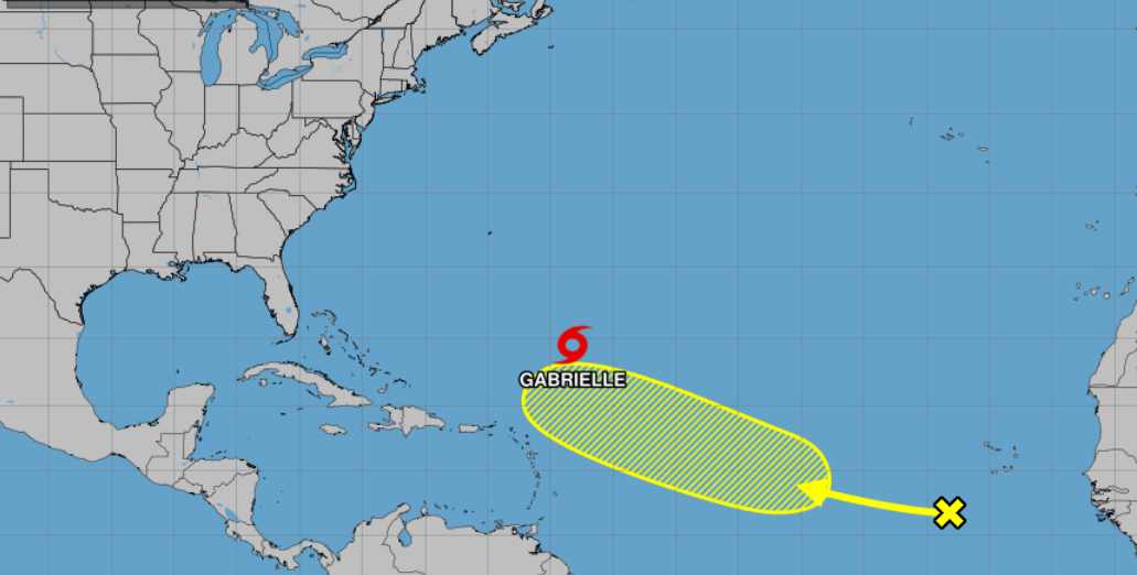
Tropical Storm Gabrielle continues its northwestward trek across the Atlantic and is expected to strengthen into a hurricane by Sunday, according to the latest advisory from the National Hurricane Center (NHC). The storm is forecast to pass east of Bermuda Sunday night into Monday, potentially bringing tropical storm conditions to the island.
As of 5 AM AST (0900 UTC) Saturday, September 20, Gabrielle was located near latitude 24.3 North, longitude 58.1 West, about 685 miles southeast of Bermuda. The storm is moving northwest at 13 mph with maximum sustained winds of 50 mph and higher gusts. The minimum central pressure is 1004 millibars.
“Gradual strengthening is forecast, and Gabrielle is expected to become a hurricane by Sunday,” the NHC stated in its advisory. The forecast shows Gabrielle potentially reaching Category 2 strength with winds of 105 mph by Monday evening.
Satellite imagery reveals Gabrielle’s low-level center is currently obscured by high cirrus clouds and remains west of the deep convective mass due to moderate westerly wind shear. According to the NHC, “The convection itself has been quite intense, with a high density of lightning co-located with cloud-top temperatures as cold as -85 to -90 degrees Celsius.”
Tropical-storm-force winds extend outward up to 140 miles from the center, but only on the eastern side. Recent ASCAT satellite data showed no tropical-storm-force winds on Gabrielle’s western side, creating an asymmetric wind field.
Similar Posts
While there are currently no coastal watches or warnings in effect, the NHC advises that “interests in Bermuda should monitor the progress of Gabrielle.” The storm has a 35% cumulative probability of producing tropical-storm-force winds in Bermuda, with a 6% chance of winds reaching 50 knots (58 mph) and a 2% chance of hurricane-force winds.
On the forecast track, Gabrielle will make a gradual turn toward the north-northwest on Sunday, followed by turns toward the north and northeast on Monday and Monday night. All reliable track models continue to keep the core of the storm well east of Bermuda during its recurvature, though some impacts remain possible.
Swells generated by Gabrielle are already beginning to reach Bermuda and will build through the weekend. “These swells are likely to cause life-threatening surf and rip current conditions,” the NHC warned. Current seas near Gabrielle’s center are running about 14 feet (4 meters) and are expected to increase significantly as the storm strengthens.

After passing Bermuda, Gabrielle is projected to accelerate northeastward into the open Atlantic. The NHC forecasts it will maintain hurricane strength through Wednesday before gradually weakening. By Thursday, September 25, the storm is expected to be near latitude 38.7 North, longitude 38.5 West with winds of 65 knots (75 mph).
Gabrielle ended an unprecedented 20-day quiet period in the Atlantic, the longest stretch without a named storm during peak hurricane season since satellite monitoring began in 1966. The 2025 Atlantic hurricane season continues to run below the forecasted activity level, with Gabrielle being only the seventh named storm so far.