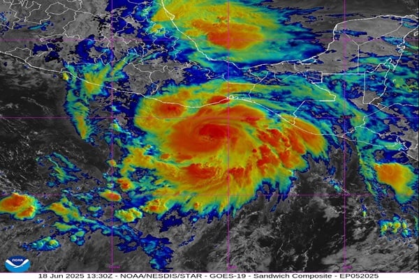
Hurricane Erick is gaining strength quickly in the Eastern Pacific and poses a serious threat to Mexico’s southern coast. Weather experts warn it could become a major hurricane before hitting land late Wednesday night or early Thursday.
Erick was elevated to hurricane level early Wednesday, becoming the second hurricane in the 2025 Eastern Pacific hurricane season. Weather measurements taken at 11 a.m. ET Wednesday showed Erick packing sustained winds reaching almost 85 mph, with even more intense bursts.
“We expect Erick to drift northwestward and close in on the southwestern coast of Mexico,” said AccuWeather Lead Hurricane Expert Alex DaSilva. “Erick will rapidly strengthen for a time as it approaches the coast.”
The National Hurricane Center (NHC) has issued a hurricane warning from Acapulco to Puerto Angel and a hurricane watch from west of Acapulco to Texpan de Galeana. Officials stress that “preparations to protect life and property should be rushed to completion.”
Dangerous Impacts Expected
The storm threatens to bring several life-threatening hazards:
Torrential downpours pose a significant risk, with forecasts predicting between 8 and 16 inches of rainfall throughout the Oaxaca and Guerrero regions. Some areas could see up to 20 inches, leading to dangerous flash floods and mudslides, especially in mountainous regions. Lighter but still significant rainfall of 3 to 5 inches is forecast for Chiapas, Michoacan, Colima, Jalisco and Mexico City.
Powerful winds could cause widespread damage. The NHC warns that “devastating wind damage is possible where the core of the storm moves onshore.” If Erick reaches Category 3 status (winds of 111-129 mph), it could cause “major damage or removal of roof decking” from well-built homes, according to NOAA.
Storm surge along the coast will create flooding and “large and destructive waves,” threatening coastal communities.
Similar Posts:
Concern for Acapulco
Acapulco faces special concern, having suffered catastrophic damage from Category 5 Hurricane Otis just last October. Otis claimed numerous lives and caused extensive destruction after strengthening at an extraordinary rate – its wind speeds surged by 115 mph within 24 hours, marking the second-most rapid intensification ever recorded in modern weather history.
“Erick may track very close to Acapulco with the full impacts you would expect from a hurricane, ranging from powerful wind gusts and power outages to torrential rain and flash flooding, as well as storm surge flooding,” DaSilva noted.
Mexican authorities have taken several precautionary measures:
- Mexico’s civil protection plan has been activated
- Thousands of troops are being deployed to affected areas
- Schools have been closed in at-risk regions
- Acapulco’s port was closed Tuesday evening
- 582 shelters have been prepared across Guerrero state
Mexico’s President Claudia Sheinbaum and the Governor of Guerrero, Evelyn Salgado, have called on local populations to remain vigilant and carefully follow official guidance.
Active Hurricane Season
Erick marks the fifth named storm and second hurricane of the 2025 Eastern Pacific hurricane season, which is running ahead of the historical average. Typically, the fourth tropical storm doesn’t form until mid-July, and the average date for the first hurricane is not until June 26.
The storm’s formation on June 17 makes it the earliest fifth-named storm in the Eastern Pacific since July 9, 1956. The average date for the fifth-named storm is July 23.

AccuWeather meteorologists expect 14-18 tropical storms for the entire eastern Pacific season, with seven to ten becoming hurricanes. Of these, three to six are forecast to directly impact Mexico and Central America.
While the Atlantic basin remains quiet for now, with no immediate threats of development, weather experts continue to monitor the southwestern Gulf and western Caribbean for potential tropical development in late June.
Hurricane Erick serves as a reminder that even in a season predicted to be less active, a single powerful storm can cause widespread disaster and significant impacts.
