 Govind Tekale
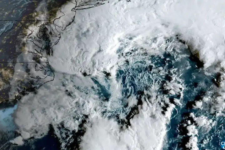
A nor’easter struck the US Northeast bringing dangerous coastal flooding to New York City, Long Island, and coastal New Jersey. If you are in a coastal borough, near shoreline parking, or planning to commute, the late-morning high tide is the most dangerous window of the day. Here is what is happening and what you need to do before it peaks.
Core Facts
- Wind speeds: 50–60 mph sustained, gusting higher (per initial advisories)
- Rainfall: 2–4 inches
- Storm surge: 2.0 to 3.5 feet above astronomical high tide
- Peak flood window: approximately 10:30 AM to 1:00 PM EST
- Airports: Ground stops at JFK, LaGuardia, and Newark
- Active flood zones: Jamaica Bay, Raritan Bay, western Long Island Sound, New York Harbor
National Weather Service coastal flood warnings are in effect across the region. NYC Emergency Management has issued active advisories. Verify current conditions via NWS and NYC Emergency Management as the situation develops.
Move Your Vehicle Before 10 AM
If you have a vehicle parked on a shoreline street, a low-lying coastal road, or in a ground-level garage in a flood zone, move it to an elevated structure before 10 AM. Saltwater submersion destroys automotive electronics — even a brief soak in seawater can cause permanent failure in a modern car’s control modules, sensors, and wiring harness. For electric vehicles, the risk is more acute: saltwater intrusion into a lithium-ion battery pack can cause thermal runaway, which in some cases produces a fire that is difficult to extinguish. This has been documented after previous storm surge events in the New York area.
Belt Parkway, FDR Drive, and other low-lying coastal routes are subject to closure. Check NYC DOT and 511NY for current road status.
Why This Flood Is More Severe Than the Rainfall Suggests
The storm surge is not just a function of how hard it is raining. Two conditions are stacking this week: the nor’easter is arriving during a perigean spring tide — a period when the Moon is closest to Earth and tides are naturally higher than average — and a stalled Atlantic low-pressure system is pushing sustained easterly winds directly into New York Harbor and Jamaica Bay.
What that means in practice: coastal bays that normally drain seaward during an ebb tide cannot drain against the storm’s wind-driven push. Back-bay water levels rise even before the next high tide begins. Municipal storm drains in low-lying coastal blocks of Brooklyn, Queens, and coastal Staten Island are connected to the same drainage system. When bay water levels exceed the drain outlets, stormwater flapper gates — one-way valves that normally prevent backflow — are submerged and held shut by the hydrostatic pressure of the elevated bay. Inland storm drains then reverse: seawater backs up through street-level grates, flooding blocks that are nowhere near the shoreline. Residents report this as what looks like the street itself flooding from below — because, functionally, it is.
This back-flooding dynamic can persist for several hours after the high tide peak passes and the coastal surge begins to retreat. Read our guide to understanding urban flood risk for more on how coastal drainage systems work.
Subway and Transit Status
MTA service on coastal-adjacent lines is subject to suspension or significant delay during the peak surge window. Check the MTA website or the MYmta app for live service status. Commuter rail services on the LIRR and Metro-North may also see delays on low-lying sections of track.
After the Peak Tide
Flooding can persist for several hours after the high-tide window as waterlogged roads and disrupted drainage take time to clear. Check local emergency management resources and the Notify NYC app for clearance updates.
Related Karmactive coverage: Earlier Nor’easter East Coast Impacts provide additional context for this story.