 Sonali Tiwary
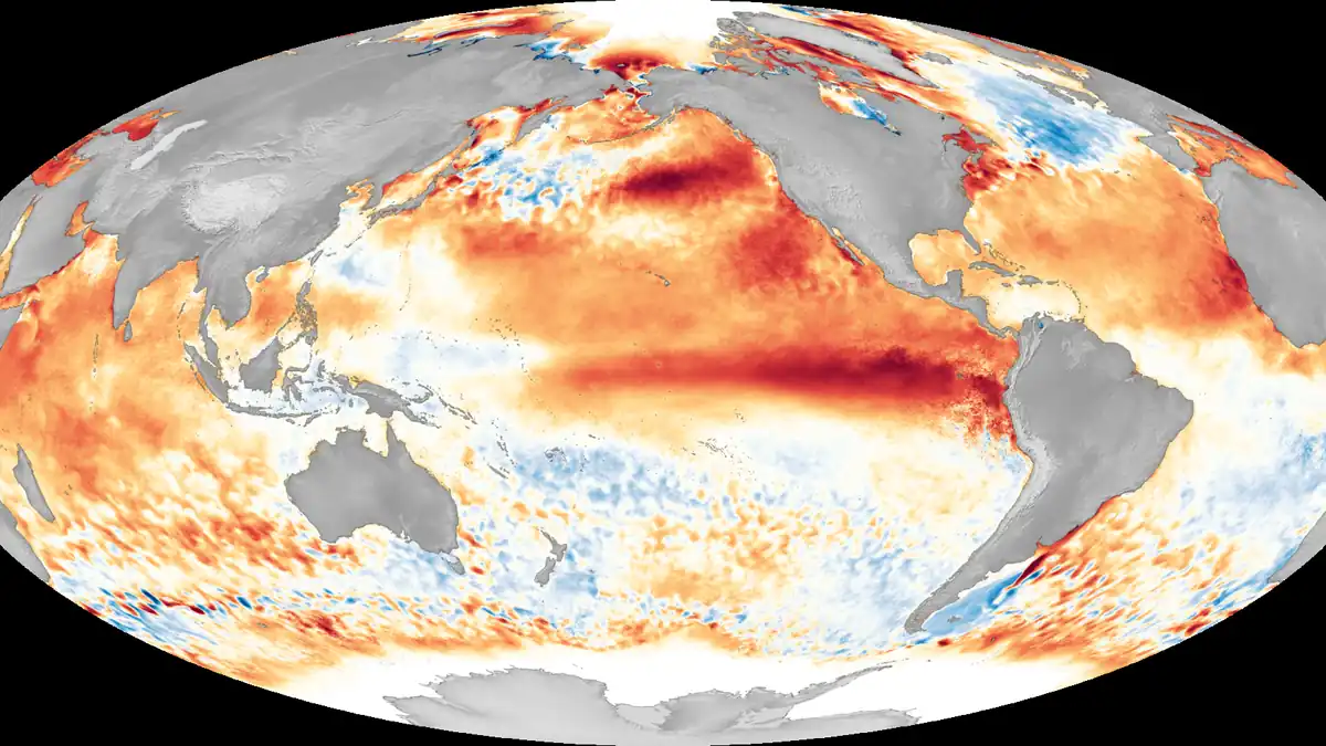
Winter arrived two months early this year — record autumn rain in the Southwest, a record-warm September across much of the country, and an Atlantic hurricane season that produced eight named storms but not a single hurricane. NOAA says there’s an 83% chance the event driving all of it becomes the strongest El Niño on record.
NOAA’s Climate Prediction Center reported on November 9 that ocean temperatures in the key equatorial Pacific zone reached +2.0°C under its newer Relative Oceanic Niño Index (RONI), a measure the agency adopted on February 1, 2026 specifically to strip out the effect of long-term ocean warming so El Niño strength can be compared fairly across decades. Near the South American coast, anomalies hit +4.7°C. NOAA puts the odds at 83% that the October–December three-month average will exceed +2.5°C, which would top the previous records set in 1982–83 and 2015–16.
That matters beyond the headlines: where you live largely decides whether this winter means flooding or drought, extra snow or none at all. The southern tier — from California through the Gulf Coast and Southeast — faces a higher chance of a wetter winter with periodic atmospheric-river storms, while the northern tier leans milder than usual. Skiers should weigh elevation and region carefully rather than assume one national story applies everywhere, and water managers and farmers should treat NOAA’s seasonal odds as probabilities, not guarantees.
US Winter Outlook by Region
NOAA’s December–February outlook favors a warmer-than-normal pattern across Alaska, the Pacific Northwest, the Northern Plains, the Midwest and the Northeast, while the South — California, the Southwest, the Southern Plains and the Gulf and Southeast — leans wetter. California has already moved to shore up coastal flood defenses ahead of the wet season. The Southeast’s drought-to-downpour whiplash raises a secondary risk: ice storms if cold air intrudes during a wet pattern.
The 2026–27 Ski Playbook by Elevation
Snow outcomes this winter depend heavily on elevation, not just region. Forecasters favor the Southern Rockies — including Taos, which reopens November 26 — and the upper reaches of the Sierra Nevada above roughly 8,000 feet. Lower-elevation Pacific Northwest base areas face a tougher setup, with a higher risk of rain intruding on what would normally be snow.
Subsurface Peak and Climate Whiplash
NOAA’s most recent data reveals a telling wrinkle: deep-ocean heat in the central and eastern Pacific had already begun easing slightly by early November even as surface readings kept climbing, a signal some forecasters read as an early hint that the event may begin loosening its grip by spring 2027. That doesn’t change this winter’s odds, but it’s a detail largely missing from mainstream coverage of the “record” framing.
Is the 2026–27 El Niño already the strongest on record?
It’s very likely to become so. NOAA gives an 83% probability that the October–December three-month RONI value will exceed +2.5°C, which would surpass the 1982–83 and 2015–16 events dating back to 1950. A small number of daily readings have already touched record territory, but NOAA’s official measure uses a longer three-month average, so final confirmation depends on upcoming monthly updates.
Which US ski resorts benefit most from a Super El Niño winter?
Higher-elevation resorts in the Southern Rockies and above roughly 8,000 feet in the Sierra Nevada are generally favored, while lower-elevation Pacific Northwest bases face more rain risk.
Why did NOAA switch to a new index for measuring El Niño strength?
The agency adopted the Relative Oceanic Niño Index on February 1, 2026 because the older fixed-baseline index was increasingly distorted by long-term background ocean warming, making it harder to compare today’s El Niño fairly against events from past decades.
Watch for NOAA’s November monthly ENSO update, which will either confirm or adjust these odds, and for ski resorts’ opening-week snow reports over Thanksgiving week.