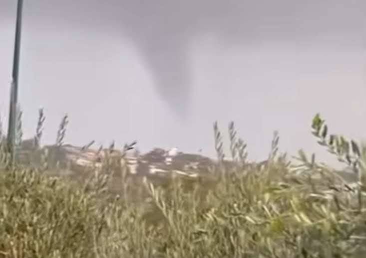
A waterspout that transformed into a tornado struck Perth’s coastal suburb of City Beach around 5:25 pm Wednesday, tearing roofs from luxury homes and uprooting trees in what residents described as sounding “like a jet engine.” The sudden weather event triggered 105 calls for help to the Department of Fire and Emergency Services (DFES), with damage concentrated on Kalari Drive, Lentara Crescent, and Marapana Road.
https://www.facebook.com/share/v/14Gu9hZd6to
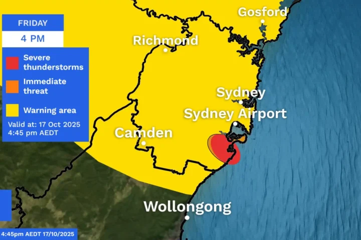
Bureau of Meteorology (BOM) meteorologist Jessica Lingard confirmed the event was indeed a tornado, explaining it “maybe started off as a waterspout, then managed to make that sea-land boundary crossing and hold its steam together to produce that damage.” The storm was detected on radar around 5:25 pm and classified as “low-intensity” in BOM’s initial assessment, with wind gusts reaching up to 87 km/h at Rottnest Island and 106 km/h at Garden Island.
One family on Kalari Drive was relaxing in their living room when the tornado tore the roof off their master bedroom. “I heard a huge bang and I thought all the windows would implode,” a family member told reporters. Solar panels from their home were dislodged and scattered across nearby yards, adding to the destruction.
City Beach artist John Major narrowly escaped serious injury. He was in his shed when he heard what sounded like a plane crash. His wife, who was watching TV inside their home, began screaming as a massive piece of wood struck a corner pillar of the house. “If that piece of wood had gone through that window, my wife would be dead,” Major said.
Local resident Tilly described the frightening moment when she spotted the tornado approaching. “I literally just looked up through the window and dead set saw a tornado,” she told ABC Radio Perth. “There was like a column of swirling wind, there was things flying in the air, bits of roof flying, tree branches, rubbish.” Concerned for her safety, she ducked under a table for protection.
When City Beach resident Anita McSweeney returned home after the storm, she was shocked by the scene. “I can only describe it as devastation,” she said. “West Coast Highway was covered in huge branches, which I tried to move off the road for the traffic, and the pathway was just covered.”
While the most severe impacts were in City Beach, damage was reported across Perth’s metro area from Baldivis in the south to Lesmurdie in the east. The Bureau of Meteorology indicated that damage in Perth’s eastern suburb of Rivervale was probably not from a tornado but more likely from a localized event such as a microburst.
Western Australian Planning Minister John Carey noted the unusual nature of the event, stating, “These are scenes that we associate with the US. To see mini-tornadoes is quite extraordinary.” He confirmed approximately 150 State Emergency Service (SES) volunteers were deployed to assist with recovery efforts.
The DFES issued a storm advice alert on Wednesday evening, urging people to “AVOID THE AREA – CITY BEACH.” This alert was downgraded on Thursday afternoon when the immediate threat had passed, though residents were still advised to exercise caution around fallen trees, damaged buildings, and debris.
The Town of Cambridge says it is setting up a cleanup hotline and has asked residents to use its “Report It” portal for damage photos. Major routes were briefly obstructed by debris, with large branches partially blocking traffic following the storm.
This isn’t the first tornado to strike Western Australia recently. A similar event caused substantial damage in Bunbury in May 2024, with disaster assistance made available under the joint Commonwealth-State Disaster Recovery Funding Arrangements (DRFA). According to BOM’s outreach information, southwest Western Australia averages approximately five cool-season tornadoes annually, making it Australia’s most tornado-prone region outside the tropics.

For anyone requiring assistance with storm damage, the SES can be contacted at 132 500 for temporary repairs. DFES recommends photographing damage before contacting insurance companies, and keeping clear of fallen power lines.
The Bureau of Meteorology’s forecast for the coming days indicates partly cloudy conditions with a medium chance of showers becoming less likely throughout Thursday morning. Small hail remains possible, with southerly winds of 15-25 km/h becoming light by evening.