7.4-Magnitude Earthquake Hits Molucca Sea Near Ternate, Indonesia
One fatality confirmed in North Sulawesi. Tsunami warning issued for 1,000 km of coastline — lifted two hours later. Buildings damaged, 48 aftershocks recorded with the largest at M5.5.

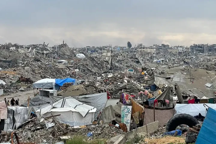
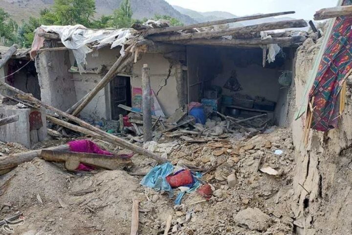
Debris and displaced furniture inside a building in North Sulawesi after the magnitude 7.4 earthquake near Ternate. Authorities reported structural damage and urged coastal vigilance following brief tsunami alerts. (Photo: BNPB / Badan Nasional Penanggulangan Bencana)
USGS / Mw 7.6 BMKG
Below Seabed
North Minahasa
by 09:50 WIB
A magnitude 7.4 earthquake struck the Molucca Sea at 05:48 local time (WIB) on Thursday, April 2, 2026, with its epicentre located approximately 127 km west-northwest of Ternate in Indonesia’s North Maluku province, according to the United States Geological Survey (USGS). Indonesia’s meteorology agency BMKG revised the magnitude to 7.6, placing the quake at coordinates 1.25° N, 126.27° E at a depth of 33 km — USGS placed the depth at 35 km.
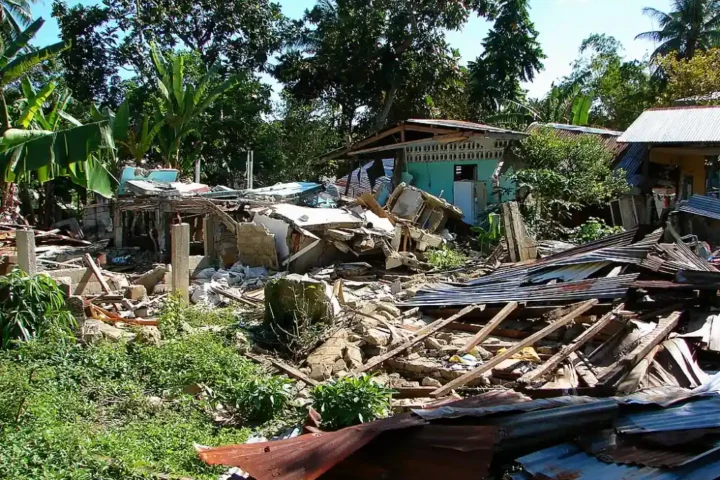
One person was killed — a 70-year-old woman in Manado, North Sulawesi — after being struck by falling debris when a building collapsed. Another resident sustained a leg injury during evacuation, according to search and rescue officials. Strong shaking lasting 10 to 20 seconds was felt across North Maluku and North Sulawesi, including the cities of Ternate, Manado, Bitung, and Tidore. Some residents described it as the most powerful tremor they had experienced in at least six years.
A simulated seismic waveform showing the P-wave and S-wave pattern typical of a thrust-fault rupture at 35 km depth. Use the buttons below to compare quake intensities.
Actual wave heights recorded at tide gauge stations following the quake, per BMKG and U.S. Tsunami Warning Centers. Hover each bar for details.
By 09:50 WIB, BMKG had recorded 48 aftershocks following the main event. The largest reported by BMKG was M5.5.
depth
depth
depth
“It was really strong… My head even felt dizzy. Even the roads outside the house were shaking. It feels like the strongest I’ve experienced over the past six years.”
“I often experience tremors, but they’re never as strong as this one. Everything started shaking at the market. Several stores had power outages, people fled. I headed straight for my child’s school — it’s very close to the sea.”
“The walls in my house vibrated for what felt like more than a minute. There were many people outside. I even saw some people leaving their house without having finished their shower.”
“We were sitting there drinking tea… didn’t realise it was an earthquake. Then we heard a child scream, ‘Come down, hurry up.’ Everyone was huddled together outside — some in wheelchairs, others helping each other.”
Eyewitness accounts sourced from AFP, BBC Indonesian, and Antara news agency direct reporting from the field.
Damage Across Three Cities
Indonesia’s National Disaster Management Agency (BNPB) described structural damage as “minor to moderate” across affected areas. The Head of BNPB flew to Manado to lead rapid damage assessments. Authorities urged the public to refrain from returning to beaches or coastal areas until officially cleared.
At Universitas Khairun in Ternate, some campus buildings sustained light cracks and ceiling damage. Classes were immediately halted and students were sent home as a precaution. The university’s response reflected a broader pattern of institutional caution seen across the region following the tremors.
The Halmahera Slab & Ring of Fire
BMKG Head Teuku Faisal Fathani confirmed the quake resulted from a thrust fault mechanism involving the Halmahera slab — an inverted U-shaped tectonic structure fully subducted beneath the Molucca Sea, with no surface expression. The Sunda and Philippine Sea plates converge in this region at approximately 100 mm per year, making it one of the most seismically active zones on Earth.
According to USGS seismic records, nine other earthquakes exceeding magnitude 7 have struck within 250 km of Thursday’s epicentre over the past 50 years — most causing limited damage due to their offshore location. Indonesia’s position on the Pacific Ring of Fire means active tectonic convergence is a permanent geological feature of the archipelago.
Epicentre & Affected Areas
The quake’s epicentre sat in the Molucca Sea, 129 km southeast of Bitung — between the islands of Sulawesi and Maluku. Click any marker for details.
Historical Scale
The Molucca Sea region has a documented history of high-magnitude seismic events. The 2004 Indian Ocean earthquake and tsunami — centred off Aceh — killed more than 230,000 people across a dozen countries, the majority in Indonesia. A 2018 Sulawesi earthquake and tsunami killed over 4,300 people. In 2022, a magnitude 5.6 quake in Cianjur, West Java, killed at least 602. Thursday’s event, while damaging, produced comparatively limited casualties, in part due to its offshore epicentre and the speed of the early warning response.
Japan’s Meteorological Agency reported only minor sea-level changes along its coastlines and no tsunami damage expected. The Philippine Institute of Volcanology and Seismology and Australia’s Bureau of Meteorology both confirmed no tsunami threat to their territories after monitoring confirmed the waves were dissipating.
The earthquake near Ternate was recorded at magnitude 7.4 by USGS and updated to M7.6 by BMKG. One fatality and structural damage were confirmed across parts of North Sulawesi and North Maluku. Tsunami warnings were issued for approximately two hours before being lifted by BMKG and the Pacific Tsunami Warning Center after wave activity was recorded at limited heights — the highest at 0.75 metres in North Minahasa. Over 48 aftershocks followed the main event. Damage assessments by BNPB remained ongoing throughout the day. Official advisories on coastal safety and aftershock vigilance were issued by Indonesian authorities.