Australia Braces for Catastrophic Flooding: Tropical Lows Unleash Record Rainfall Across Queensland and NT
Two tropical low-pressure systems are producing heavy rainfall across Australia’s tropical north. As of Friday afternoon, Katherine in the Northern Territory faces its worst flood disaster in decades, with the Katherine River expected to reach major flood levels. Simultaneously, Far North Queensland is grappling with intense rainfall from a second tropical system that has already brought 467mm to Yandill, north of the Daintree region, and over 200mm to Cooktown.
This convergence of severe weather threatens millions across Queensland and the Northern Territory. The Bureau of Meteorology has issued major flood warnings for multiple river systems and predicts continued heavy rainfall through the weekend as both systems track inland, bringing the risk of widespread flooding to already saturated catchments.
Emergency response teams are working around the clock. Understanding flood preparedness and mitigation strategies is critical as communities brace for impact. Read on for real-time developments and what residents should know about the unfolding crisis.
🌊 Critical Impact Tracker: Live Flooding Status
Interactive overview of the most affected areas and real-time metrics
About 34 patients evacuated from Katherine Hospital, with 21 flown to other health facilities. Emergency department established at St John Ambulance headquarters. Major flood warning active.
Daintree Ferry broke its moorings. River rose significantly above major flood level. Infrastructure and local businesses damaged.
Severe weather warning active. Catchments saturated. Further warnings possible.
System moving further west. Additional warnings likely for Top End towards WA border.
Rainfall Accumulation by Location
Comparing recorded and forecast rainfall totals across affected regions
Rainfall totals of 292-467mm over 24-48 hours represent extreme weather events. These volumes saturate soil and overwhelm river systems, leading to major flooding. For context, normal monthly rainfall in these regions is often in the range of 100-200mm.
The Unfolding Crisis: Dual Tropical Lows Strike Northern Australia
Two tropical low-pressure systems are working in tandem to deliver unprecedented flooding across Australia’s tropical north. The first system crossed the Far North Queensland coast near Innisfail on Friday afternoon, while a second continues to impact the Katherine region in the Northern Territory.
Katherine Hospital has been evacuated with about 34 patients, of which 21 have been flown to other health facilities. An emergency department has been established at the St John Ambulance headquarters in the industrial area. The Katherine River, which reached 16.75 metres Friday morning, is expected to climb to 17.5 metres—the major flood level. The town, 300km south of Darwin, now faces its worst flood disaster in decades.
Bureau of Meteorology flood monitoring warns that further rainfall expected Friday will cause additional river level rises. The major flood warning extends to nearby Nitmiluk and surrounding areas as authorities prepare for the worst.
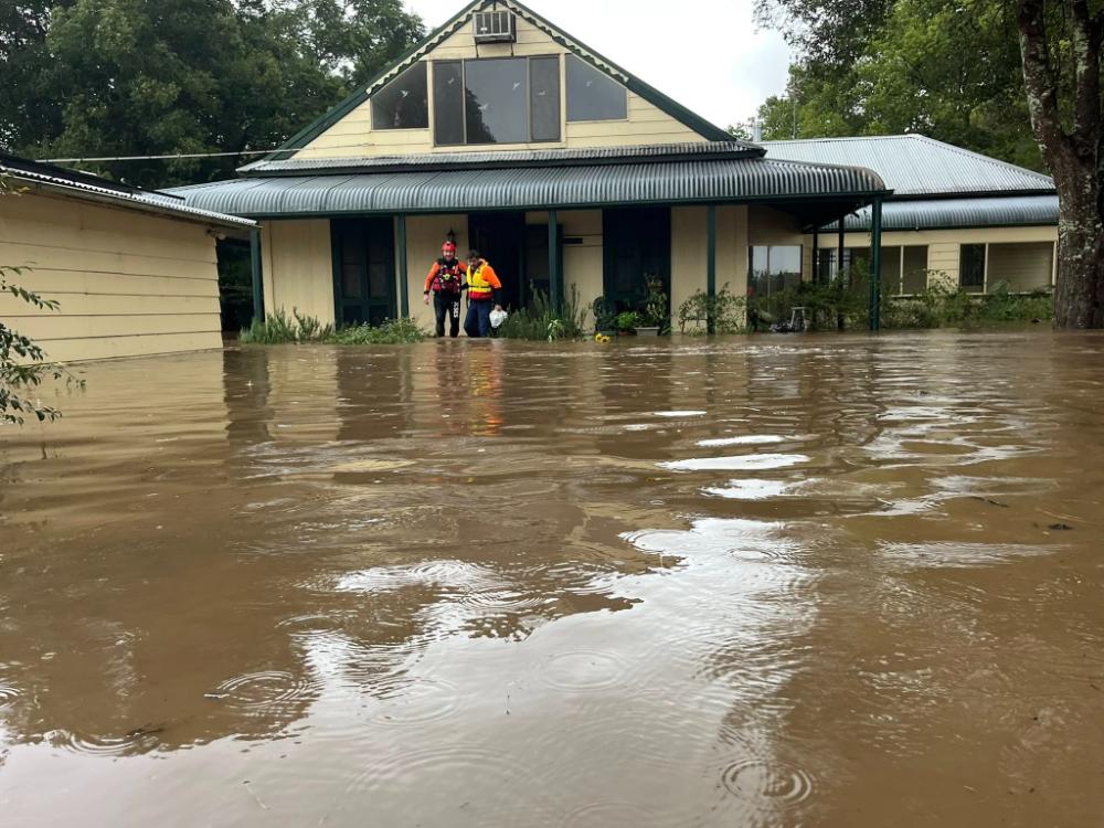
In Far North Queensland, the situation is equally severe. The Daintree River rose significantly above major flood level within hours of the rainfall onset. The Daintree Ferry broke from its moorings overnight and required emergency retrieval efforts once conditions allowed. Local operators reported infrastructure damage across the region, with an entire boat ramp ripped from the riverbank.
Douglas Shire Council’s disaster dashboard tracks real-time river heights and camera feeds of affected areas. Residents have documented swift water damage to homes, vehicles, and essential infrastructure across the region.
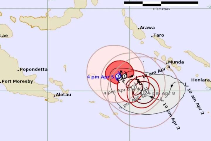
System Track and Extended Forecast
The tropical low that impacted the Daintree region and Cooktown area is now moving inland and gradually turning southward. Bureau of Meteorology forecasts show the system will track inland and then bend toward the south over the weekend, drawing tropical moisture inland. This will result in a significant rainfall band affecting most northern, central, and eastern Queensland districts.
The system is expected to reach Brisbane and the southeast coast by Sunday, bringing rain to a vast stretch of Queensland including Townsville, Mackay, the Wide Bay, Darling Downs, the Sunshine Coast, and Gold Coast. Bureau forecasters indicated that Saturday would see initial showers building toward evening, with Sunday representing the wettest day across southeast Queensland.
Brisbane & Southeast: Moderate rainfall totals of 50-100mm expected Sunday, with potential for higher isolated falls. Maximum temperature slightly cooler at 26°C.
Severe Weather Warning Zone: Heavy to locally intense rainfall across northern Peninsula, Gulf Country, Tablelands, and Northern Goldfields, with 80-240mm six-hourly totals and 300mm possible in 24 hours.
River Catchments: Already saturated from recent rainfall. Further flood warnings are likely as river systems continue to rise.
This convergence of events means communities from north Queensland to the Gold Coast must prepare for a wet weekend. Extreme flooding threatens populations and critical infrastructure globally, and Australia is now at the center of this crisis.
Emergency Response: Preparation and Deployment
State and federal emergency services have mobilized rapidly. Queensland Fire Department personnel were pre-positioned across coastal and inland communities ahead of the tropical low’s landfall, with 50 additional staff deployed into the Far North region. Northern Territory emergency services coordinated evacuation procedures and established emergency shelters across Katherine, with three schools set up to accommodate up to 850 people.
Queensland Operations
Extra crews pre-deployed from Cooktown to Halifax. Dynamic response teams staged in Mareeba ready to respond west if range access closes. Additional boat and four operators sent to Douglas Shire Council.
State Emergency Services
27 jobs undertaken across the far northern region, focused on sandbagging and precautionary measures. Evacuation centers established in accordance with emergency protocols.
Swift Water Rescue
Specialized teams equipped for rapid water rescue positioned throughout affected regions. Northern Territory emergency services coordinating with Queensland operations for seamless response across state borders.
Hospital & Health Response
Katherine Hospital successfully evacuated with patients transferred to secure facilities. Emergency department operations transferred to St John Ambulance headquarters. NT Health services coordinating emergency protocols.
Community Alerts & Shelters
SecureNT alerts system providing real-time updates to residents. Emergency declaration issued for Katherine and surrounding areas. Three emergency shelters activated with capacity for 850 people.
Supply Chain & Support
Government agencies coordinating supplies and support for affected communities. Northern Region Controller James O’Brien emphasized supply chain stability, urging residents to remain calm while authorities maintained logistical support.
Acting Superintendent Neal Gatti of Cairns North zone stated: “We’ve pre-deployed extra crews from Cooktown to Halifax, and we’ll be dynamic with the weather as it changes and moves south.” This commitment to proactive deployment reflects lessons learned from previous flood events and underscores the severity authorities expect.
Community Experience: Learning from Recent Disasters
For many residents in flood-affected areas, this is not their first brush with disaster. Just over a year ago, widespread flooding damaged homes and destroyed bridges and roads in towns between Townsville and Cairns. Communities are now bracing for another significant event.
Ingham resident Mark Wanless, whose home was damaged by previous floods, has witnessed the devastation firsthand. “Last February, we had three-quarters of a metre of water right through the house, we got smashed,” he said. His cautious assessment of the current system reflects community resilience: “This weather event coming now is not going to be as severe.”
However, resilience does not eliminate risk. The alarming surge of extreme precipitation threatens mountain and lowland regions globally as climate patterns shift. Each flood event leaves communities more vulnerable to the next, particularly in regions facing repeated rainfall events.
Flooding damages critical services—hospitals, power systems, water supplies—that take weeks to restore. Agricultural impacts affect food security. Infrastructure damage to roads and bridges isolates communities. Over 3,700 endangered species face extinction pressure from natural disasters, reflecting ecosystem fragility in flood-prone regions.
Extreme Precipitation and Climate Patterns: The Bigger Picture
This dual tropical low event is not isolated. Extreme precipitation events are increasing globally, with climate shifts intensifying rainfall systems in tropical and subtropical regions. Australia, positioned in these vulnerable latitudes, faces mounting frequency of severe weather events.
Bureau of Meteorology forecaster Harry Clarke described rainfall totals in the Daintree to Cooktown region as “phenomenal rainfall totals”—language reflecting the extraordinary nature of the event. Falls exceeding 300-400mm over 24-48 hours push rainfall records and overwhelm natural and engineered drainage systems designed for more moderate events.
Extreme weather patterns are affecting agriculture and ecosystems worldwide, creating interconnected challenges for food security and environmental stability. Australia’s experience is part of a global climate resilience challenge.
Communities in flood-prone regions must shift from reactive emergency response to proactive preparedness. Understanding solutions to avoid floods includes infrastructure investment, land-use planning, and ecological restoration. Early warning systems, evacuation protocols, and supply chain resilience are essential components of community survival.
What to Expect: Timeline and Ongoing Threats
Friday Evening & Night: Heaviest rainfall expected in northern Queensland and Northern Territory. Katherine River expected to peak around 17.5 metres. Major flood warnings in effect. Daly River and northern Top End monitoring intensifies.
Saturday: System moves inland and southward. Initial light showers in southeast Queensland building toward evening. Emergency response teams continue operations in Far North regions. Damage assessment begins in accessible areas.
Sunday: Wettest day across southeast Queensland. Moderate rainfall totals 50-100mm expected, with potential for isolated higher falls. Brisbane, Sunshine Coast, and Gold Coast enter active rainfall period. Extended emergency response period begins.
Beyond the Event: Damage assessment, recovery operations, and rebuilding efforts will extend for weeks and months. Countries and communities are developing strategies to confront climate change after record-breaking disasters. Australia must similarly invest in long-term resilience infrastructure.
River catchments remain saturated through the extended forecast period. Any additional rainfall system poses renewed flood risk to already overwhelmed waterways. Bureau of Meteorology continues to monitor conditions and issue warnings as needed.
Summary: A Watershed Moment for Australia’s Northern Regions
This dual tropical low event represents one of the most significant weather systems to affect Australia’s tropical north in recent years. Katherine faces potential flood levels of 17.5 metres at the Katherine Bridge. Far North Queensland communities experienced recorded rainfall of 467mm at Yandill and up to 369mm at China Camp, with the Daintree Ferry breaking from its moorings. Emergency services mobilized comprehensively, with about 34 Katherine Hospital patients evacuated and emergency department operations transferred to St John Ambulance headquarters in the industrial area.
The article covered the critical impacts across Katherine, Daintree, Cooktown, and broader Queensland regions. Recorded rainfall totals and system forecasts predicting continued heavy precipitation through Sunday were detailed. Emergency response efforts across Queensland Fire Department, State Emergency Services, and Northern Territory agencies coordinating shelter provision and evacuation logistics were documented. Community experience and broader climate context were explored to place this event within larger environmental trends.
Official sources including the Bureau of Meteorology, SecureNT, Douglas Shire Council, NT Health, and emergency services provided data and updates. The information presented reflects current conditions and forecasts as of Friday, March 6, 2026, with emergency protocols remaining in effect through the weekend.