New York City faced a historic drenching Monday night as a powerful storm system unleashed what weather experts confirm is the second-highest hourly rainfall recorded since 1943. Water cascaded down subway stairs, flooded platforms, and turned highways into impassable waterways, leaving commuters stranded across the city.
The National Weather Service confirmed the staggering numbers: Central Park measured 2 inches of rain in a single hour between 7-8 PM. Staten Island was hit even harder with 4-6 inches reported in some areas, while Mount Joy, Pennsylvania received over 7 inches in less than five hours.
“The atmosphere is so juicy,” said Brian Hurley from the Weather Prediction Center, describing the moisture-laden air mass that collided with a stationary frontal boundary to create the perfect flood conditions.
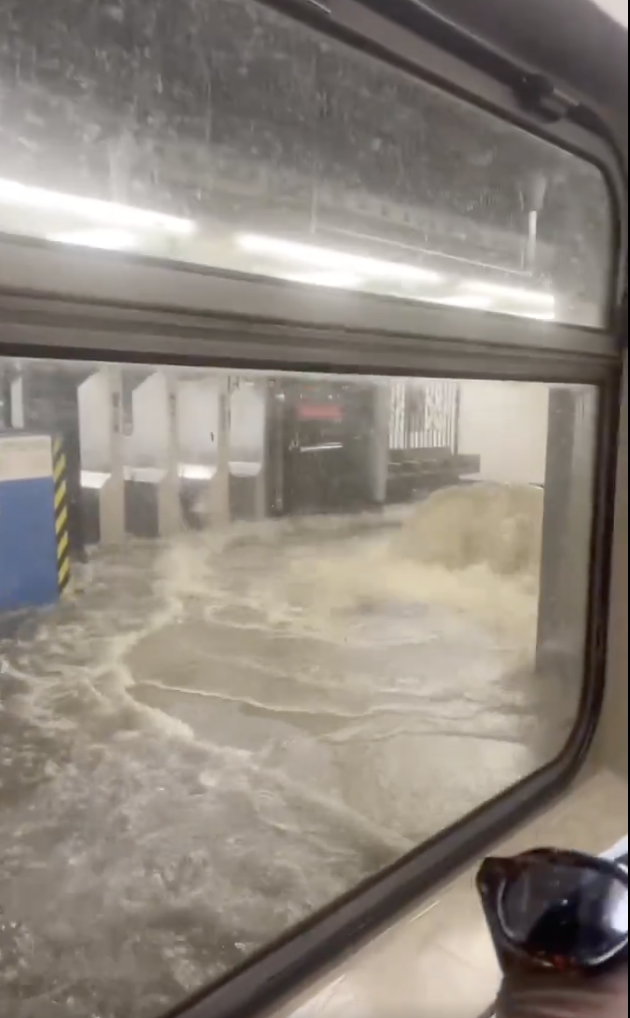
When Underground Transit Becomes Underwater
Videos from 28th Street and Penn Station showed alarming scenes of water gushing onto platforms and down stairwells. The MTA was forced to suspend service on multiple lines including the 1, 2, 3, E, M, and R as water overwhelmed the century-old drainage systems.Major roadways quickly became impassable. The Saw Mill River Parkway, Cross Bronx Expressway, and Bronx River Parkway all closed due to dangerous flooding with multiple vehicles stranded. Drivers abandoned cars as water levels rose rapidly around them.
Air travelers faced significant disruptions too. The region’s three major airports—Newark, LaGuardia, and JFK—implemented ground stops with hundreds of flights canceled or delayed as runways and access roads flooded.
Emergency Response in Action
First responders conducted multiple water rescues across the tri-state area. In Mount Joy, Pennsylvania, emergency teams performed 16 verified water rescues. The situation grew even more dangerous in North Plainfield, New Jersey, where AP News reported a house explosion occurred following the storms, though fortunately with no injuries reported.
New Jersey Governor Phil Murphy declared a state of emergency, urging residents to avoid unnecessary travel. “These conditions are extremely dangerous,” Murphy said in a statement released Monday night.
NYC Emergency Management activated the city’s Flash Flood Emergency Plan with special warnings directed to vulnerable residents: “Basements can fill within minutes during intense rainfall,” the agency warned.
Similar Posts
Power outages affected nearly 1,000 customers in Queens, according to verified reports, with utility crews working through challenging conditions to restore service.
Further south, Petersburg and Colonial Heights, Virginia faced what the National Weather Service termed “catastrophic flood risk”, requiring emergency response teams to conduct multiple water rescues.
Climate Reality Meets Urban Infrastructure
The MTA acknowledged a painful truth about the city’s infrastructure: their systems “weren’t built for this climate reality”. Most of NYC’s subway network was designed and constructed over a century ago, using rainfall patterns and expectations that no longer apply in today’s changing climate.
Weather experts note the Northeast has received rainfall amounts approximately 300% above normal for July, creating saturated soil conditions that amplify flood risks. This follows a pattern observed in previous extreme events, including the September 2023 floods that brought Central Park over 3 inches of rain in a single hour.
Local businesses felt the impact too. Dowling’s Irish Pub in Roselle Park, New Jersey reported flooding for the second time since Hurricane Ida in 2021, highlighting the recurring nature of these events for many business owners.A dramatic weather moment was captured when lightning struck the World Trade Center during the storm, creating a powerful image of nature’s force against the city’s skyline.Safety Guidance as Recovery Continues
For New Yorkers navigating the aftermath:
- Avoid flooded areas where hidden electrical hazards may exist
- Never drive through flooded roadways—just 6 inches of moving water can sweep away a vehicle
- Check MTA and DOT updates before traveling today
- Keep emergency supplies accessible
Weather forecasters expect improving conditions throughout Tuesday, but caution that saturated ground means even moderate additional rainfall could trigger localized flooding. The NYC Department of Environmental Protection has deployed teams to clear clogged storm drains in flood-prone areas.

For real-time transit updates, residents should check the MTA website or NJ Transit portal. The National Weather Service continues to monitor conditions, with flood watches remaining in effect for parts of the region.
This storm joins a troubling pattern of extreme precipitation events affecting the Northeast with increasing frequency, a trend that puts pressure on aging urban infrastructure and emergency response systems. Similar challenges were recently seen in Texas and China, where record rainfall has caused significant human and economic impacts.