A stubborn bubble of hot air has settled over the eastern United States, trapping nearly 100 million people under heat alerts as temperatures soar to triple digits. The heat dome, stretching from the Mississippi River to the Atlantic coast, brings both scorching daytime highs and dangerously warm nights that offer little relief.
“This event shows all the hallmarks of climate change influence,” said Dr. Kristina Dahl, climate scientist with Climate Central. “Our analysis indicates about 160 million Americans are experiencing temperatures that are at least three times more likely due to human-caused warming.”
The heat dome formed when a high-pressure system stalled over the Tennessee Valley, creating a zone where sinking air becomes compressed and heats up. As this hot air gets trapped and compressed, it creates a feedback loop of rising temperatures and humidity.
In Birmingham, Alabama, overnight lows reached 78°F on July 22. In Tuscaloosa, Alabama, overnight lows reached 77°F on July 18-19, setting a new warm-night record. These high minimum temperatures are particularly dangerous as they prevent bodies from recovering overnight.
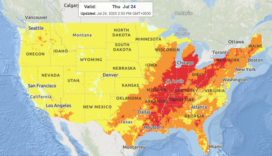
The National Weather Service’s HeatRisk map shows “extreme” risk levels across much of the Southeast and Mid-Atlantic, with heat indices (what it actually feels like) reaching up to around 110°F along the Mississippi corridor. Humidity levels are further amplified by what meteorologists call “corn sweat” – moisture released by crops in the Midwest that adds to the already oppressive conditions.
ERCOT, which manages Texas’s power grid, reported forecast operating margins were narrow with peak loads approaching 79 gigawatts on July 24, nearing record territory. The organization monitored conditions as air conditioners strain the system.
Cities are responding with emergency measures. St. Louis County activated public cooling centers after the National Weather Service upgraded heat advisories. New York City activated its Cooling Center Finder and implemented “Code Red” outreach for unsheltered residents.

The CDC recommends checking on older adults twice daily when HeatRisk levels reach 3 or higher. The American Red Cross advises drinking one cup of water per hour and avoiding caffeinated beverages during extreme heat events.
According to NOAA’s Climate Prediction Center, the heat event is occurring during ENSO-neutral conditions, when Pacific Ocean temperatures are neither in El Niño nor La Niña states. This suggests the extreme heat is driven more by background warming than by natural climate cycles.
The upper-level high pressure system is forecast to stall over the Tennessee Valley before gradually weakening after July 26, according to the Weather Prediction Center. Until then, health officials urge people to stay hydrated, limit outdoor activity during peak afternoon hours, and use cooling centers if needed.
The repeated heat events raise concerns about flash drought development, particularly in the south-central U.S., according to USGS research linking heat domes to escalating drought risk – a significant concern for agriculture and water supplies in affected regions.
The dome is expected to persist through the weekend before any meaningful relief arrives for most affected areas.