M5.4 Bangladesh Quake —
Kolkata Shakes, Offices Evacuate
The ground beneath Kolkata and the Ganges-Brahmaputra Delta trembled on Friday, February 27, 2026, as a 5.4-magnitude earthquake struck near the India-Bangladesh border. The event at approximately 1:22 PM IST sent thousands of office workers and residents in Salt Lake and Rajarhat onto the streets. No casualties were reported. The National Centre for Seismology and the European-Mediterranean Seismological Centre are monitoring for aftershocks.

A digital seismometer registers sharp seismic waves during a tremor event — similar to what monitoring centres recorded on Feb 27. (Photo: Representative/AI-generated illustration)
Earthquake Data at a Glance
Three independent seismological agencies recorded this event. Their initial readings differ slightly — normal in early reporting, as each uses different station networks. Figures below from EMSC, USGS, and NCS India.
Why Do Agencies Report Different Magnitudes?
Each seismological network receives signals from different station arrays at different latencies. Automatic readings are published within minutes but revised as more data arrives. A ±0.1–0.3 difference is within expected scientific bounds.
| Agency | Magnitude | Depth | Type |
|---|---|---|---|
| EMSC — European-Mediterranean Seismological Centreemsc-csem.org ↗ | M 5.4 | 35 km | Auto · Initial |
| USGS — United States Geological Surveyearthquake.usgs.gov ↗ | M 5.3 | ~35 km | Auto · Initial |
| BMD — Bangladesh Meteorological Departmentbmd.gov.bd ↗ | M ~5.1 | Pending | Local Bureau |
| NCS — National Centre for Seismology, Indiaseismo.gov.in ↗ | M ~5.0 | 35 km | Felt Reports Active |
Cross-agency note: Always anchor verified magnitude, depth and coordinates to official agency pages — EMSC, USGS, NCS or BMD — not secondary sources. Values will be revised as more stations report in. Check live felt-area reports at riseq.seismo.gov.in.
What Happened on February 27
A factual chronological account — from the seismic parameters and local impact, to the science explaining why Kolkata felt the quake so strongly from 75 km away.
On Friday, February 27, 2026 at approximately 1:22 PM IST, a 5.4-magnitude earthquake struck near the Satkhira district in the Khulna Division of south-west Bangladesh, according to data from the European-Mediterranean Seismological Centre (EMSC) and independently confirmed by the United States Geological Survey (USGS). The epicentre was at approximately 22.45°N, 89.14°E — roughly 26 km south-east of Taki, West Bengal.
The EMSC recorded a focal depth of 35 km. Initial mobile earthquake alerts received by Kolkata residents showed a magnitude of approximately 5 with the epicentre listed at about 8 km from the city — early automatic readings that were subsequently revised. Strong tremors spread across Kolkata and several adjoining districts of West Bengal within seconds of the event. Shaking lasted from a few seconds to approximately five minutes in some high-rise locations — a duration attributed to soil amplification by soft deltaic sediment beneath the city.
Thousands of employees in commercial hubs including Salt Lake, Rajarhat and Sector V evacuated offices and gathered in open spaces as a precautionary measure. Swaying ceiling fans, rattling windows and vibrating furniture were widely reported. People captured the moment on mobile phones; videos and screenshots of earthquake alerts spread rapidly on social media. ANI published footage showing Kolkata residents evacuating buildings.
Local Impact & “The Jelly Effect”
The epicentre was over 70 km from central Kolkata — yet people in high-rise buildings felt pronounced, prolonged swaying. The explanation lies in soil amplification. Kolkata sits on thick layers of soft, water-saturated alluvial sediment — the Ganges delta. During an earthquake, this material acts like a bowl of jelly: it slows incoming seismic waves while increasing their amplitude, producing stronger and longer shaking at the surface than the quake’s distance alone would predict.
Research from the National Information Centre of Earthquake Engineering at IIT Kanpur and the Geological Survey of India classifies much of the Kolkata metropolitan area as high-risk for soil liquefaction — a process where water-saturated sandy soil can temporarily lose its bearing strength under strong shaking and behave like a liquid, potentially destabilising building foundations.
“The unconsolidated fluvial deposits of the Bengal Basin pose a unique risk of soil liquefaction. Under strong shaking, the water-saturated sandy soil can temporarily lose its strength and behave like a liquid, potentially destabilising foundations.” — West Bengal Disaster Management Department seismic reports.
The event followed a week of elevated seismic activity. On February 26, two earthquakes — M4.6 and M3.5 — struck Sikkim, with epicentres in Gyalshing and Mangan districts at 10 km depth, according to the National Centre for Seismology (NCS). On February 6, a M4.5 quake struck the same Sikkim region and was followed by at least 12 aftershocks within four and a half hours. February 2026 recorded over 50 tremors across the Darjeeling and Sikkim regions.
Factors Often Missed in Immediate Coverage
The epicentre lies near the Eocene Hinge Zone — a structural feature of the Bengal Basin where basement rock dips sharply and stress accumulates. A USGS publication on the décollement below eastern Bangladesh documents the seismic hazard tied to this buried fault structure, as the Indian plate moves northward beneath the Eurasian plate. The cluster of tremors across the Tista Fault and Kabaw Fault systems in February 2026 indicates an active period of tectonic adjustment in the region.
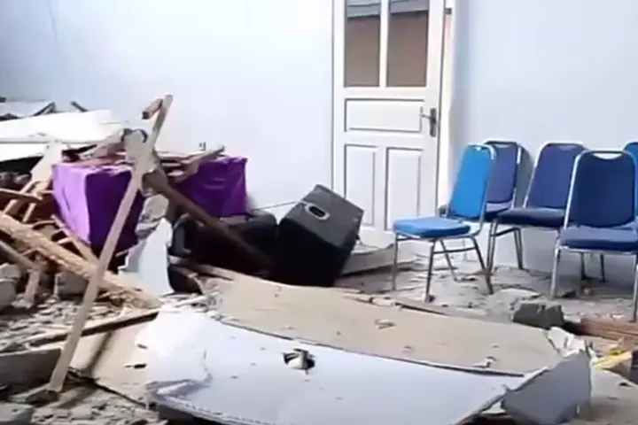
The September 18, 2011 M6.9 Sikkim earthquake — the largest in the region in recent decades — occurred on the same broader fault network. The February 27 epicentre is south of that 2011 event, in a structurally distinct but connected zone. Kolkata is classified under India’s seismic Zone III (Moderate Damage Risk Zone). Experts at NICEE, IIT Kanpur note that the cumulative effect of repeated moderate quakes on soft-soil foundations requires ongoing review of building bylaws specific to alluvial delta zones. Non-structural failures — falling plaster, ceiling tiles, glass facades — cause the majority of injuries in urban areas during moderate seismic events.
Summary of Coverage
The event on February 27, 2026 was a 5.4-magnitude earthquake with its epicentre in the Khulna region of Bangladesh. The coverage discussed the seismic parameters — a depth of 35 km, coordinates at 22.45°N, 89.14°E, and proximity to the India-Bangladesh border. The findings indicated that tremors were felt extensively across Kolkata and adjoining districts due to wave amplification by deltaic soil. Evacuations in commercial hubs including Salt Lake and Rajarhat, the social media response, and the historical context of Bengal Basin tectonic activity were all addressed. Expert warnings regarding soil liquefaction and building resilience in Zone III were covered. No casualties or major structural damage were reported as of 13:56 IST. The disaster response framework at national and state levels remained on monitoring status.
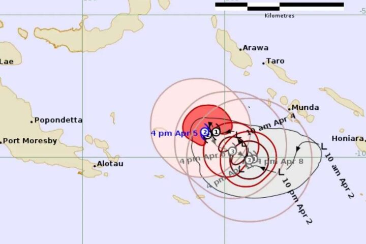
Epicentre & Felt Zones
The epicentre was in Khulna Division, south-west Bangladesh — roughly 75 km from central Kolkata. Click any marker for details. Distance rings at 50, 100, and 200 km show why tremors reached so far through soft deltaic sediment.
Depth matters: The 35 km focal depth is intermediate — deeper than a shallow quake (under 10 km, which causes far greater surface destruction) but shallow enough for seismic energy to propagate efficiently through soft sediment. Source: EMSC / USGS
How the Day Unfolded
A chronological record — from elevated seismic activity in the days prior, through the main shock, to official confirmations. All times IST. All data from official seismological sources.
Why Did Kolkata Shake So Hard?
The epicentre was roughly 75 km away. Yet people in high-rises felt significant swaying for several minutes. The answer is in the ground beneath the city — and the deep tectonic forces at work across the Bengal Basin.
Interactive MMI Scale — Tap or Hover Each Level
The Modified Mercalli Intensity (MMI) scale measures how strongly a quake is felt at the surface — not energy released. The Feb 27 epicentral area reached approximately MMI V–VI. Kolkata experienced approximately MMI III–IV.
Detected only by instruments.
Felt by very few at rest, especially upper floors.
Felt indoors. Hanging objects swing slightly.
Felt by many indoors. Dishes & windows rattle.
Felt by nearly all. Small objects displaced.
Felt by all. Heavy furniture moved. Plaster cracks.
Considerable damage to poorly-built structures.
Partial collapse of ordinary masonry.
Damage to well-built structures. Pipes broken.
Most masonry destroyed. Rails bent.
Few structures remain standing.
Objects thrown into air. Ground distorted.
The September 18, 2011 M6.9 Sikkim earthquake remains the largest in this region in recent decades, causing structural damage and fatalities across the same fault network connected to the Feb 27 zone. Source: NCS India · KarmActive Earth Science
What to Do When the Ground Shakes
Based on guidelines from the National Disaster Management Authority (NDMA) and the UN Office for Disaster Risk Reduction (UNDRR). These actions can make a critical difference in the first few seconds of shaking.
- Drop, Cover, Hold On — get under a sturdy desk or table
- Stay away from windows and glass facades
- Do not run outside while shaking continues
- Move away from bookshelves and heavy furniture
- Protect your head and neck with arms if no table nearby
- Never use elevators — they can lose power or jam
- Move away from exterior glass walls
- Take cover under a desk or strong interior doorframe
- Use stairwells only after shaking fully stops
- Falling plaster and debris cause most urban injuries
- Move away from buildings, trees, and power lines
- Open grounds like parks are safest
- Watch for falling signage and glass from buildings
- If near a river or coast — move to higher ground
- Check yourself for injuries before moving
- Check for gas leaks — do not use open flames
- Follow official updates before re-entering buildings
- Expect aftershocks — leave damaged structures
- Do not share unverified clips — wait for agency confirmations
Test Your Earthquake Knowledge
Six questions — all based on verified facts from this event and seismological science. Each answer includes a full explanation.