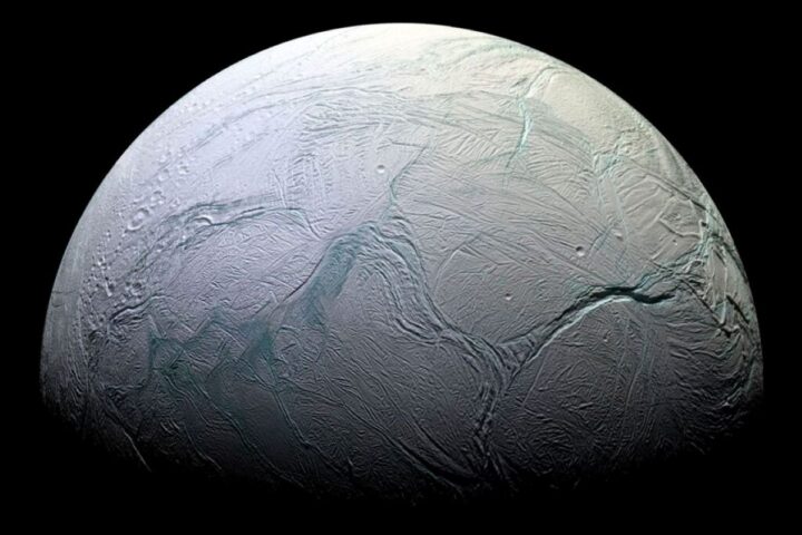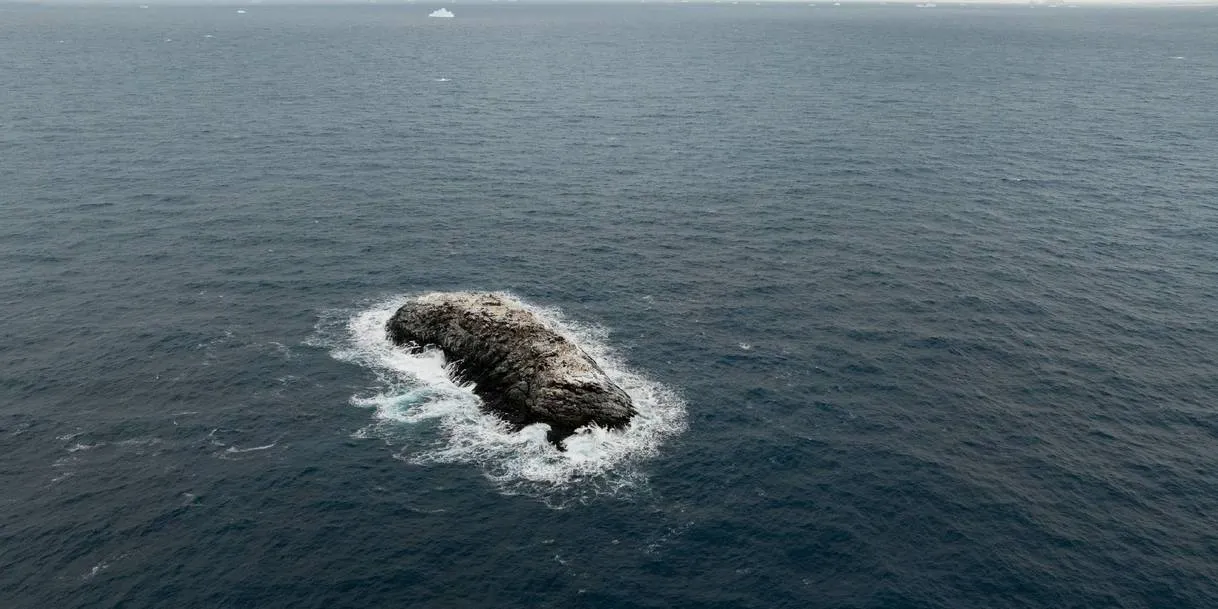
In early 2026, the crew of the German research icebreaker Polarstern was sheltering from rough weather near Joinville Island in the northwestern Weddell Sea when a bathymetry specialist noticed something odd from the bridge — an “iceberg” with dark, dirty-looking patches. It was not an iceberg. It was an island.
The Alfred Wegener Institute (AWI) — Germany’s federal centre for polar and marine research — confirmed the find. The island had appeared on some nautical charts before, but only as an ambiguous “danger to navigation,” and its plotted position was about one nautical mile (~1.85 km) from where it actually sits. No official name, no measured coastline, no clear entry in international mapping datasets.
The broader expedition, called SWOS (Summer Weddell Sea Outflow Study), was focused on tracking cold-water outflow from the Larsen Ice Shelf, measuring sea ice thickness, and monitoring the accelerating changes in Antarctic sea ice that have been tracked since 2017. The island was an accidental find during a forced weather detour.
“I scoured all the coastlines we had here in the bathymetry lab and went back to the bridge. Looking out of the window, we saw an ‘iceberg’ that looked kind of dirty. On closer inspection, we realized that it was probably rock. We then changed course and headed in that direction and it became increasingly clear that we had an island in front of us.”— Simon Dreutter, Bathymetry Section, Alfred Wegener Institute
By the Numbers: The Island
How the Discovery Unfolded
A 93-member international team begins the SWOS expedition from Punta Arenas, Chile. The primary focus: Larsen Ice Shelf cold-water outflow, sea ice conditions, and the region’s sharp sea ice decline since 2017.
Rough weather interrupts field operations. The ship seeks shelter in the lee of Joinville Island — a routine detour that brings the crew to an area marked on nautical charts only as a vague “danger zone.”
AWI bathymetry specialist Simon Dreutter notices a dark-patched object from the bridge window. He checks coastal databases in the bathymetry lab, finds no match, returns to the bridge, and the ship changes course toward the object.
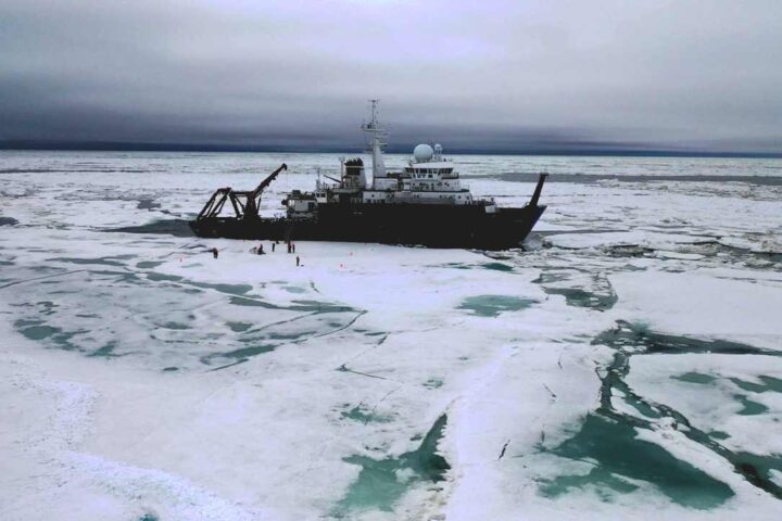
The ship approaches to within 150 metres, maintaining at least 50 metres of water under the keel throughout. It circumnavigates the island. A drone captures aerial photogrammetry; the onboard multibeam echo sounder maps the surrounding seafloor. This is the first systematic survey of the island.
The island has no official name yet. Once the formal international naming process is completed, its exact coordinates will be published and the island will be added to navigational charts and the IBCSO database.
Why It Was Not Clearly Represented in Mapping Datasets
The island is covered in ice and sits among dozens of drifting icebergs in the same area. From orbital altitude, it is hardly distinguishable from the surrounding floating ice — the satellite images analysed by the AWI team confirm this. The island’s position had been entered into some nautical charts before, but approximately one nautical mile (~1.85 km) off from its actual location. The label used was “danger to navigation” rather than “coastline,” which meant it was never added to standard coastal or island databases.
This is a known limitation of polar seafloor and coastal mapping. In regions like the Weddell Sea, where ice cover is persistent and research vessel access is rare, bathymetric surveys rely heavily on interpolation. As the General Bathymetric Chart of the Oceans (GEBCO) mapping standards explain, sparse measurement coverage means unmapped objects can effectively be erased during data processing. Without physical ground-truthing — exactly what the Polarstern crew carried out — such objects remain absent from datasets.
Iceberg or Island? Why the Difference Matters
Hover or tap each side to explore how these two formations differ — and why confusing them creates a navigation risk.
From the Field


What Else the Expedition Recorded
The island was one unexpected data point within a much larger scientific mission. Prof. Dr. Christian Haas, head of the expedition and AWI’s Sea Ice Physics division, reported considerable ice thickness variability across the survey area. Ice on the western continental shelf reached up to four metres in places — thickened by tidal deformation and proximity to the coast. Ice further east, originating from the Ronne and Filchner ice shelves, measured around 1.5 metres and showed less physical stress.
More notable was the surface condition. The expedition found widespread surface melting that led to almost Arctic conditions, where the ice is typically covered with melt ponds. Snow cover was minimal in many areas; the ice had a bluish-grey appearance. Using turbulence and biological probes under the ice, the team detected larger quantities of freshwater meltwater. These freshwater lenses sit above the denser saltwater beneath, acting as an insulating layer that keeps ocean heat away from the ice above. Similarities with Arctic processes were noted, as Arctic sea ice behaviour has been changing over a longer timeframe.
The Weddell Sea’s northwestern shelf has seen a sharp decline in summer sea ice extent since 2017, presumably as a result of warmer surface water. AWI has been collecting long-term oceanographic measurements in this region through the Hybrid Antarctic Float Observing System (HAFOS) since 2002 — a dataset that gives the current changes meaningful historical context. The expedition also tracked outflow paths of cold dense water from the Larsen Ice Shelf, which contributes to global ocean circulation and influences heat distribution in the deep ocean.
Sea Ice Thickness — SWOS 2026 Findings
Measured ice thickness varied considerably across the survey area, reflecting different formation conditions.
Four Reasons This Discovery Matters
What Happens Next
Test Your Antarctic Knowledge
Three quick questions based on what you just read.
Covered in This Report
This report covered the discovery of an uncharted island in the northwestern Weddell Sea during the 2026 SWOS expedition aboard the Polarstern icebreaker, including its dimensions (approximately 130 m × 50 m, rising 16 m above the waterline), the survey methods used, and the circumstances that led to the find. It included details on the island’s prior misrepresentation in nautical charts — plotted about one nautical mile (~1.85 km) from its actual position — and the satellite imagery limitations that kept it from being correctly identified.
The report also covered the expedition’s broader findings: sea ice thickness variability across the Weddell Sea, surface melt conditions resembling those seen in the Arctic, freshwater meltwater behaviour under the ice, and the ongoing decline in Antarctic summer sea ice extent since 2017, presumably linked to warmer surface water. The naming and international registration process for the island was described, as were the planned steps for updating navigational and bathymetric databases, and the post-expedition analysis connected to the broader context of polar ice research.