When China’s devastating Wenchuan Earthquake struck in May 2008, its immediate destruction made headlines worldwide. But 17 years later, researchers have discovered that rivers in the region are still feeling the effects – and will continue to do so for decades to come.
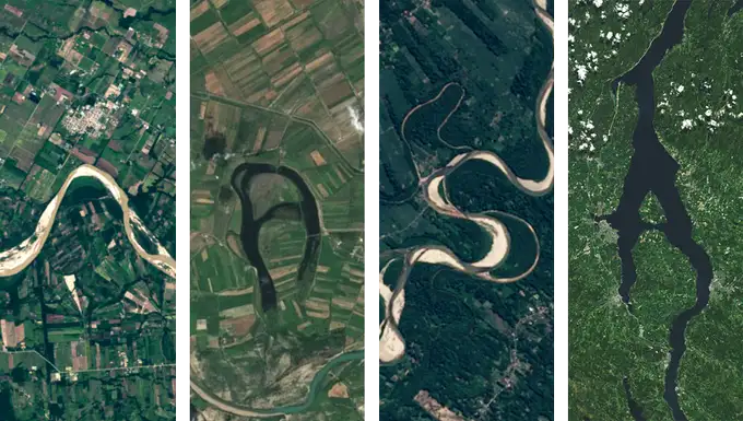
A new study published in Nature on August 14, 2025, reveals that the Min River, which flows through the earthquake zone, has been carrying far more sediment than normal for at least a decade after the quake – with no signs of returning to pre-earthquake levels.
“Before our work, people mostly focused on sediment of very fine size,” explains Gen Li, the study’s lead author. But it’s the coarser material – known as bedload – that’s causing the most significant and lasting changes to the river.
The research team, which includes Professor Alexander Densmore from Durham University, used data from the Zipingpu Dam located about 20 kilometers downstream from the earthquake’s epicenter. Their findings paint a concerning picture of long-term flood risks that outlast the immediate earthquake recovery.
Numbers Tell the Story
The magnitude 7.9 earthquake triggered more than 60,000 landslides across the Longmen Shan mountains in Sichuan Province. These landslides dumped massive amounts of rock and soil into the river systems.
The team’s measurements show that total sediment flowing through the Min River increased roughly six times above normal levels and remained elevated for at least ten years. Even more striking, the coarse bedload – consisting of gravel and boulders that roll along the riverbed – surged by approximately 20-27 times.
This coarse material now makes up about 65% of all sediment moving through the river, far higher than the typical 20% found in similar mountain rivers.
Despite a decade of high flows, only about 9% of the landslide debris has been removed from the landscape. At current rates, scientists estimate it could take centuries for rivers to clear away all the material deposited by the earthquake.
Hidden Dangers Downstream
When rivers carry more coarse material than they can transport effectively, it builds up on the riverbed – a process called aggradation. This raises the height of the riverbed and reduces the channel’s capacity, making it easier for water to overflow the banks during rainy seasons.
For communities downstream of earthquake zones, this means flood risks remain elevated long after rebuilding efforts have concluded – a danger that traditional disaster recovery planning often overlooks.
The elevated flood risk poses serious challenges for infrastructure like bridges, dams, and riverside communities. As riverbeds rise, bridges may have less clearance, dam reservoirs fill with sediment faster than designed, and low-lying areas become more vulnerable to flooding.
Beyond Immediate Hazards
The research also contributes to understanding how earthquakes influence long-term mountain building processes. Scientists have debated whether large earthquakes primarily build mountains by pushing land upward or wear them down through erosion and wetlands.
This study suggests the answer depends partly on how quickly rivers can evacuate earthquake debris – a process that works on timescales of decades to centuries rather than the years typically considered in post-disaster recovery.
The findings highlight the need for longer-term monitoring of river systems after major earthquakes and more careful planning for communities in these regions. With the knowledge that hazards persist long after the ground stops shaking, planners and engineers can better design infrastructure and flood protection systems to withstand these extended impacts.
As climate change potentially brings more extreme rainfall events to many mountainous regions, understanding these long-lasting effects becomes even more crucial for protecting vulnerable communities downstream of earthquake zones.