A 4.3-magnitude earthquake struck near Muscoy in San Bernardino County at 9:32 a.m. today, July 31, 2025. The quake originated at a depth of 5.3 kilometers (about 3.3 miles), according to the United States Geological Survey (USGS). Nearly 5,000 residents reported feeling the tremor through the USGS “Did You Feel It?” system within hours of the event.
The main quake was followed by a 3.1 magnitude aftershock near Rialto at 9:36 a.m., just four minutes after the initial event. Earlier this morning, two smaller tremors of 3.0 and 2.8 magnitude were recorded at 8:34 a.m. and 8:42 a.m. respectively near Fontana.
Rialto Fire Department officials report no damage as of early afternoon. “We’re conducting routine checks of critical infrastructure as a precaution.”
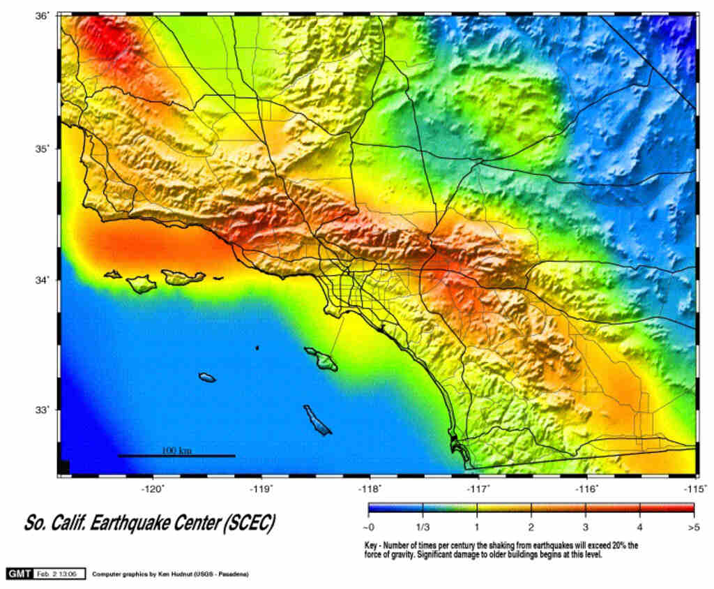
Residents felt shaking across a wide area from Santa Clarita to San Diego. The USGS intensity map shows strongest effects (Intensity 4 – light shaking) near the epicenter, with Intensity 2-3 (weak shaking) reported across most of Los Angeles, San Diego, and Ventura counties.
Today’s earthquake occurred on the Mill Creek strand of the San Jacinto Fault Zone – one of Southern California’s most active fault systems with slip rates up to 12 millimeters per year. The San Jacinto Fault Zone runs parallel to the San Andreas Fault and is capable of producing significant earthquakes.
Seismologist Dr. Lucy Jones has previously noted that this area typically produces several magnitude-3 events yearly. Clustering of quakes is common after regional stress changes.
Similar Posts
The ShakeAlert earthquake early warning system detected the initial P-waves from today’s quake, providing seconds of warning before stronger shaking arrived. This technology, developed by the USGS in partnership with the California Governor’s Office of Emergency Services (Cal OES), monitors ground motion sensors across the state to detect earthquakes before humans can feel them.
Recently upgraded with GPS capabilities in June 2024, the ShakeAlert system now provides more accurate magnitude estimates for larger earthquakes. The system delivers alerts through multiple channels: the MyShake app (available for iOS and Android), Android Earthquake Alerts, and Wireless Emergency Alerts for larger events.
Today’s quake comes just days after tsunami warnings were lifted across the Pacific following Wednesday’s magnitude 8.8 earthquake off Russia’s Kamchatka Peninsula. However, seismologists have not established any connection between the distant Russian quake and today’s local seismic activity.
Buildings in the Inland Empire fall under California’s Alquist-Priolo earthquake fault zones, which require structures to meet specific seismic standards. The San Bernardino area sits atop several active faults, making earthquake preparedness especially important for local residents.
Based on USGS data, California experiences approximately 25 earthquakes of magnitude 4.0-5.0 per year. While today’s event serves as a reminder of the region’s seismic activity, it falls within the normal pattern for Southern California.

Emergency management officials recommend having emergency kits ready with water (one gallon per person per day), non-perishable food, flashlights, batteries, first-aid supplies, and masks for post-quake dust. The most effective protective action during an earthquake remains “Drop, Cover, Hold On” – get under sturdy furniture, protect your head and neck, and hold on until shaking stops.
Residents can report their earthquake experiences through the USGS “Did You Feel It?” tool, which helps scientists gather valuable data on how earthquakes affect different areas. The USGS continues to monitor for additional aftershocks, which commonly follow earthquakes of this magnitude.