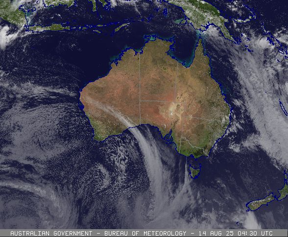
A powerful cold front is sweeping across Australia, bringing damaging winds to Western Australia before moving eastward to deliver thunderstorms, hail, and snow to the southern and eastern states over the coming days.
Western Australia Hit First
The Bureau of Meteorology (BOM) has issued a severe weather warning for south-western Western Australia, with the fast-moving cold front expected to reach Perth around 7:00 PM local time on Wednesday, August 13.
“A burst of strong to damaging winds is on the way for south-western WA,” the BOM stated in their latest update. The warning extends from just north of Perth down to around Walpole, with wind gusts of 90-100 km/h possible through late Wednesday afternoon and evening.
The strongest winds are expected precisely when the frontal system arrives, potentially coinciding with showers and thunderstorms, creating “a very active and disturbed spell of weather,” according to the Bureau’s forecast.
Large waves will also be whipped up along the coastline, driven by these powerful winds. The severe weather may cause damage to trees and branches that could fall onto property, vehicles, and potentially damage crops in agricultural regions.
System Moving Eastward
After impacting Western Australia, the weather system will continue eastward, reaching South Australia overnight into Friday morning, bringing strong winds and rainfall. By Friday, the system will affect Victoria and Tasmania.
The cold front is expected to bring gusty winds, showers, small hail, and a lowering snow level to southeastern areas starting Friday and continuing through the weekend. Alpine regions of Tasmania, Victoria, and potentially southern New South Wales may experience strong or damaging wind gusts.
“Temperatures will drop away across the south-east as we move into the weekend, and we could well see some low-level snow fall across south-eastern parts of the country during the weekend as well,” the BOM meteorologist explained.
Cold Air Mass and Unusual Winter Conditions
A notable feature of this system is the pool of very cold air that will move across southeastern Australia. This air mass is shown as whites and pinks on the Bureau’s forecast maps, indicating very cold air.
For Tasmania, the snow level is expected to drop as low as 800 meters across northern parts and as low as 400 or 500 meters in the south by Friday’s end.
The cold upper-level air is also creating unusual winter conditions in Queensland and northern New South Wales, where thunderstorms with small hail are forecast—a less common occurrence during winter months.

State-by-State Forecast
Western Australia
Perth can expect showers with gusty winds on Wednesday night, easing on Thursday with a top temperature of 18°C. Small hail and coastal thunderstorms are possible in the wake of the frontal system.
South Australia
Adelaide will see mostly sunny conditions Thursday with a top of 20°C before the front arrives late Thursday, bringing showers overnight into Friday morning when temperatures will drop to a maximum of 16°C.
Victoria
After morning fog and frost on Thursday, Melbourne will experience increasing cloud and winds ahead of showers on Friday, with a maximum temperature of 15°C expected.
Tasmania
Hobart will be mostly sunny on Thursday (17°C) before cloud builds and showers develop on Friday (16°C), bringing possible small hail and lowering snow levels.
New South Wales and ACT
Sydney can expect a showery Thursday with a top of 17°C, followed by partly cloudy conditions Friday (19°C). Canberra will see frost followed by sun on Thursday (16°C) and partly cloudy conditions Friday (15°C).
Queensland
Brisbane will experience a few showers on Thursday (21°C) with isolated thunderstorms possible in southeastern Queensland, before partly cloudy conditions on Friday (22°C).
Northern Territory
Darwin maintains typical dry season weather with sunny days and tops of 33°C.
Climate Context
Seasonal outlooks indicate a developing negative Indian Ocean Dipole (IOD), which typically brings moisture-laden air toward southern and southeastern Australia. This pattern is expected to result in a wetter-than-average spring for much of eastern Australia.For the latest forecasts and warnings, the Bureau recommends checking their website (www.bom.gov.au) or the BOM Weather app.