Current Position & Intensity: As of 11:00 PM EDT Sunday, Tropical Depression Chantal sits approximately 60 miles southeast of Danville, Virginia, tracking northeast at 12 mph with maximum sustained winds of 30 mph. The storm’s center remains disorganized yet continues producing dangerous rainfall bands across central North Carolina.
Record-Breaking Precipitation Creates Catastrophic Conditions
The meteorological data tells a sobering story. Weather stations recorded 14 inches of rainfall in areas west of Durham within 24 hours – equivalent to two months of typical precipitation compressed into a single day. The widespread totals paint a picture of unprecedented moisture content across the Piedmont region, with 4-6 inches falling across most central counties and isolated pockets exceeding 8-9 inches.
These rainfall accumulations occurred on already saturated soils from previous summer storm activity, creating optimal conditions for rapid runoff and catastrophic flooding scenarios similar to recent dam overtopping events witnessed elsewhere in North Carolina.
Critical Infrastructure Failures Trigger Emergency Response
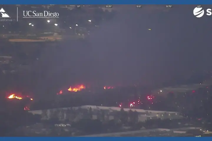
The Longleaf Dam near Southern Pines experienced complete structural failure Sunday afternoon, sending torrents of water through residential neighborhoods and commercial districts. Concurrently, the Crystal Lake dam near Lakeview reached overflow capacity, with emergency management officials warning of imminent breaching potential.
The Haw River at Bynum gauge station recorded rapid water level rises throughout Sunday evening. At 9:31 PM, the river measured 17.0 feet and surged upward by more than 4 feet within one hour and 7.7 feet over two hours. Current forecasts project the river will crest near 21.2 feet around 8:00 AM Monday morning, approaching the historic flood levels recorded during Hurricane Fran in 1996.
Moore and Orange counties activated their emergency operations centers and declared local states of emergency, implementing coordinated evacuation protocols developed for multi-hazard disaster response. Orange County Emergency Services issued immediate evacuation recommendations for residents in flood-prone and low-lying areas, emphasizing the time-sensitive nature of the threat.
Power Grid Infrastructure Under Severe Stress
Duke Energy’s outage tracking systems recorded 33,679 customers without electrical service statewide as of 10:52 PM Sunday. Orange County bears the heaviest impact with 11,200+ customers in the dark, while Chatham County follows with 3,000+ affected customers. Utility crews managed to restore power to over 15,000 customers throughout Sunday, though new outages continued developing as saturated ground conditions destabilized power poles and equipment.
The power restoration efforts face ongoing challenges from continued precipitation and saturated soil conditions that create unstable foundations for utility infrastructure. Emergency generators deployed to critical facilities including hospitals, emergency operations centers, and communication towers maintain essential services during the outage period.
Active Rescue Operations and Community Displacement
Water rescue teams deployed boat crews and swift-water swimmers across multiple counties to extract motorists trapped in flooded vehicles. The emergency response included 63 displaced residents in Chapel Hill, with 20 individuals evacuated from the historically flood-prone Camelot Village neighborhood.
Emergency responders conducted numerous technical rescues near the failed Longleaf Dam, where rising waters trapped vehicles and threatened residential structures. No fatalities have been reported, though multiple shopping centers and retail facilities sustained significant flood damage and remain closed for safety assessments.
Tornado Activity and Wind Damage Assessment
The National Weather Service issued eight tornado warnings across central North Carolina Sunday, concentrated primarily in Lee, Chatham, Orange, and Sanford counties. Confirmed tornado damage occurred at the Raleigh Executive Jetport in Sanford, where preliminary surveys documented damage to two aircraft hangars and multiple aircraft from suspected EF-0 intensity winds.
Pre-dawn tornado activity near Wilmington generated estimated wind speeds of 70 mph, while coastal wind gusts reached 56 mph during the storm’s approach. Additional tornado touchdowns occurred near Mebane in Orange County, though damage assessments remain ongoing.
Hydrological and Atmospheric Analysis
The meteorological setup creating these extreme conditions involves deep tropical moisture interacting with a slow-moving atmospheric pattern. The storm’s forward speed of 8-12 mph allows prolonged rainfall over the same geographic areas, creating training effects that maximize precipitation accumulation.
Surface observations indicate dewpoint temperatures in the mid-70s Fahrenheit, representing near-saturated atmospheric conditions optimal for heavy precipitation production. The combination of warm cloud processes and orographic enhancement along the North Carolina Piedmont contributes to the extreme rainfall rates observed.
Understanding how natural flood prevention systems typically mitigate such events provides context for the current flooding severity, as many protective wetland areas have been altered or removed from the affected watersheds over recent decades.
Ongoing Meteorological Threats
Flash flood watches remain active across central North Carolina through Monday morning, with the Weather Prediction Center maintaining a Level 2 out of 4 flood risk for the region. The atmospheric pattern supporting heavy rainfall will gradually shift northeast, transferring flood threats toward southern Virginia and the Mid-Atlantic region.
Additional rainfall totals of 2-4 inches remain possible across already saturated areas, with locally higher amounts creating compounding flood risks. The saturated ground conditions mean even moderate additional precipitation could trigger new flash flooding events in areas that have not yet experienced impacts.
Dangerous surf and rip current conditions persist along Atlantic coast beaches from northeastern Florida through the Mid-Atlantic states. The National Weather Service maintains high surf advisories and beach hazard statements as storm-generated swells continue affecting coastal areas.
Similar Posts
Current Safety Protocols and Public Health Measures
Pinehurst village utilities reported compromised water main infrastructure due to flood undermining, creating low pressure conditions throughout the distribution system. Residents received boil-water advisories that will remain in effect until pressure normalizes and water quality testing confirms safety standards.
Multiple state highway closures affect Interstate 40 and numerous secondary roads throughout the affected counties. The North Carolina Department of Transportation deployed barricades and detour signage, though several road segments experienced washout damage requiring emergency repair work.
Emergency management officials continue coordinating multi-agency response efforts, with swift-water rescue teams, utility repair crews, and damage assessment specialists deployed across the affected region. The response builds upon lessons learned from previous extreme weather events and incorporates comprehensive emergency management protocols developed for multi-hazard scenarios.

Technical Forecast and Atmospheric Evolution
Computer weather models indicate Chantal’s remnant circulation will continue tracking northeast through Virginia Monday, gradually weakening as it moves inland. The storm’s moisture content will interact with approaching frontal boundaries, potentially extending shower and thunderstorm activity through mid-week across the Mid-Atlantic region.
The broader Atlantic basin remains relatively quiet, with no additional tropical development anticipated through the next seven days according to the National Hurricane Center’s tropical outlook. However, climatological patterns suggest the early July formation of Chantal represents an unusually active start to the traditional peak season months.
Sea surface temperatures across the Atlantic development regions currently measure 1-2 degrees Fahrenheit above long-term averages, providing enhanced energy for tropical system intensification. The relationship between warming ocean temperatures and ecosystem stability continues affecting coastal protection capabilities during tropical weather events.
Conclusion
The current weather emergency across North Carolina involves multiple concurrent hazards including record rainfall, dam failures, widespread power outages, and ongoing rescue operations. Emergency management agencies continue coordinating response efforts as flood conditions persist through Monday morning. Residents in affected areas should monitor local emergency broadcasts and follow evacuation guidance from official sources.
Stay connected with real-time weather updates and emergency information at karmactive.com. Follow @karmactive on all platforms and @karmactivealive on X for continuous coverage of developing weather conditions.