NASA Landsat Satellite Imagery Spells Names with Earth’s Natural Landscapes
In April 2026, as part of Earth Day celebrations, NASA presented an interactive tool that allows people to see their names spelled using satellite photographs of Earth’s surface. The “Your Name in Landsat” tool draws from more than 50 years of continuous Earth observation data to create personalized visual displays. Users type in a name or word, and the system generates images where each letter is represented by a real landscape—a river valley, glacial formation, volcanic crater, or other natural geological feature.
The tool demonstrates the scope and continuity of the Landsat program, a partnership between NASA and the U.S. Geological Survey (USGS) that has operated since 1972. Behind the tool’s interactive appeal lies a data archive of significant scientific and economic value.
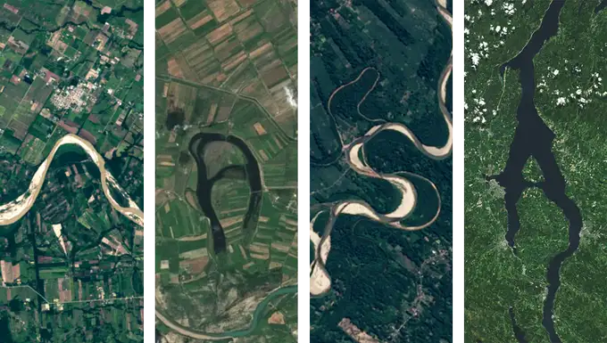
Satellite images captured by NASA’s Landsat missions reveal natural and geological formations across Earth’s diverse landscapes, highlighting how satellite observation data is used for environmental monitoring, land-use planning, and resource management. (Photo Source: NASA/USGS Landsat; public domain – U.S. Government work)
Earth’s Alphabet: Featured Landscape Examples
Explore real satellite imagery showing natural and geological formations that resemble letters from locations around the world
How the Tool Works
The “Your Name in Landsat” interactive operates straightforwardly. Users visit the NASA tool webpage, enter text into a search box, and the system generates a series of satellite images where each character is represented by a different landscape photograph. The gallery contains 72 different images sourced from global locations.
When users hover over individual letter images, the interface displays the geographic location where each photograph was taken, including latitude and longitude coordinates. This allows exploration of specific regions through mapping services or access to detailed satellite data through USGS EarthExplorer.
All images are sourced from authoritative data repositories: NASA Earth Observatory, NASA Worldview, USGS EarthExplorer, and ESA Sentinel Hub. Individual images are available for download, though they are optimized for digital use and screen viewing rather than large-format printing.
NASA describes the tool as an educational interactive designed for small groups and individual use, focused on land cover visualization and satellite data interpretation—not simply as entertainment, but as a means to engage audiences with Earth observation science.
The Landsat Program: 54 Years of Continuous Earth Observation
The “Your Name in Landsat” tool’s data comes from the Landsat program, a partnership between NASA and USGS. Landsat 1 launched on July 23, 1972, and the program has maintained an unbroken archive of Earth surface imagery since then—the longest continuous space-based record in existence. This makes Landsat the foundation for understanding environmental change at global and local scales over five decades.
Current Satellite Constellation
- Active Missions: Landsat 8 and Landsat 9 currently operate in orbit, providing global coverage.
- Daily Output: Landsat 9 collects approximately 740 scenes per day; Landsat 8 collects approximately 740 scenes per day. Combined, the two satellites capture nearly 1,500 scenes daily.
- Revisit Frequency: Each satellite has a 16-day repeat cycle; operating together with an 8-day offset, Landsat 8 and 9 enable observations of the same location every 8 days on average.
- Data Resolution: Landsat 9’s Operational Land Imager 2 (OLI-2) collects 14-bit radiometric data, compared to Landsat 8’s 12-bit data. This enhancement improves sensitivity by approximately 25 percent and provides better analysis of dark targets such as coastal waters.
The 2008 Open Data Decision
A watershed moment in Landsat’s history occurred in 2008, when NASA and USGS made all Landsat data freely and publicly accessible. This decision transformed the program from a specialized scientific tool into a global resource, enabling widespread adoption across agriculture, environmental monitoring, disaster response, and climate research. This open-access policy has contributed substantially to the economic and scientific value of the Landsat archive.
Economic Value and Scientific Applications
The Landsat program generates measurable economic benefits and supports critical scientific research. According to USGS assessment, Landsat data contributed an estimated $25.6 billion to the United States economy in 2023 alone. This value spans multiple sectors and applications.
Key Application Areas
- Deforestation Monitoring: Scientists compare imagery from 1972 to 2026 to quantify forest loss and recovery patterns across decades, tracking the speed of environmental change in tropical and boreal regions.
- Glacial and Snow Monitoring: Long-term archives enable measurement of glacial retreat velocity and changes in seasonal snow cover, providing data for climate research and water resource planning.
- Urban Growth and Land Use: Built-up areas and land-cover changes are mapped using multispectral data, informing infrastructure planning and environmental impact assessment.
- Agriculture and Crop Monitoring: Crop health, irrigation patterns, and seasonal variations in vegetation are assessed, supporting food security planning and farm management decisions.
- Water Resource Management: Lakes, rivers, and wetland changes are monitored for drought prediction, water availability assessment, and flood risk mapping.
- Disaster Response and Recovery: Wildfire extent mapping, flood inundation analysis, and post-disaster damage assessment guide emergency response and recovery planning.
NASA’s Earth Science Division operates more than 20 satellites that, in combination with Landsat data, support research on agriculture, forest management, water resources, and wildfire response. This constellation of instruments provides complementary data streams for comprehensive environmental monitoring.
Technical Capabilities Underlying the Visual Tool
While the “Your Name in Landsat” tool emphasizes accessibility and visual appeal, its technical foundation reflects decades of satellite engineering advancement. Understanding these capabilities provides context for why the Landsat data archive is considered a global scientific standard.
Radiometric Enhancement and Data Quality
Landsat 9’s 14-bit radiometric resolution (compared to earlier 8-bit systems) enables detection of subtle differences in areas that appear uniformly dark or bright to previous-generation sensors. This matters for analyzing coastal water quality changes, detecting shadows in deep canyons, and identifying subtle vegetation stress signals. The improved sensitivity benefits research on water pollution, land degradation, and environmental stress detection.
International Data Integration and Collaboration
The “Your Name in Landsat” gallery sources imagery not only from Landsat but also from data platforms hosting European Space Agency’s Sentinel missions. This integration demonstrates international cooperation in Earth observation, with data from multiple agencies accessible through unified platforms. The combination of Landsat and Sentinel data provides overlapping coverage and enables cross-validation of observations.
Data Continuity and Archive Integrity
The Landsat program prioritizes seamless transitions between satellite generations. When Landsat 9 was launched in September 2021, it was positioned in the same orbit as the retiring Landsat 7, ensuring no gaps in the 54-year observation record. This continuity is essential for accurate trend analysis, long-term climate studies, and validation of environmental change models.
Tool Development and Data Sources
The “Your Name in Landsat” interactive was developed by Ross Walter, Allison Nussbaum, and Ginger Butcher from the Landsat Project Science Support Team. The tool builds on NASA’s broader mission to communicate Earth science data to public audiences.
Landscape imagery in the tool’s 72-image gallery originates from four authoritative data sources:
- NASA Earth Observatory
- NASA Worldview
- USGS EarthExplorer
- ESA Sentinel Hub
All imagery is publicly accessible, meaning researchers, educators, and citizens can download individual satellite scenes for analysis, education, or further study through these official repositories.
Earth Day 2026 and NASA Earth Science Priorities
Earth Day, observed annually on April 22, has been recognized since 1970 as a time for environmental awareness and action. In 2026, NASA’s Earth Science Division presented the “Your Name in Landsat” tool as one component of a broader engagement strategy highlighting satellite data’s role in environmental stewardship.
NASA Kennedy Space Center announced the tool with the phrase: “The planet can spell your name—literally.” This messaging framed satellite imagery as accessible, personalized interaction with Earth observation technology—connecting abstract data with individual experience.
The timing also coincided with the Artemis II lunar mission, which launched on April 1, 2026, and returned Earth imagery captured during the mission. This alignment connected human spaceflight, lunar exploration, and Earth observation as complementary elements of NASA’s science mission.
Summary
NASA’s “Your Name in Landsat” tool was presented to the public during Earth Day 2026 as an interactive entry point to satellite imagery and environmental observation. The tool utilizes a 54-year archive of Earth observation data managed by NASA and USGS. Its 72-image gallery includes geological features and landscapes from locations spanning Brazil, Azerbaijan, Antarctica, the Kyrgyzstan mountains, and other regions worldwide. The underlying Landsat program provides free, publicly accessible data supporting scientific research and environmental monitoring, with economic benefits to the United States quantified at $25.6 billion annually. The current operational constellation includes Landsat 8 and Landsat 9, which together capture approximately 1,500 satellite scenes daily and enable observations of the same location approximately every 8 days.
For additional information, visit the official NASA Your Name in Landsat page or explore the USGS Landsat Benefits report.