Rain drummed on tin roofs across the Mid North Coast last May. Now those same communities face a new threat. Weather instruments capture the birth of another coastal tempest, this one taking shape in the warming Tasman waters off our eastern shores.
Gone are the days when a simple barometer reading might suffice. Modern forecast tools map a complex low-pressure system developing offshore, ready to unleash 50-150mm of rainfall across coastal NSW this weekend, with isolated areas possibly receiving up to 150mm. Similar rainfall measurements once came by hand-collected rain gauge readings; today they arrive through automated stations and Doppler radar networks.
“`htmlTest Your Storm Prep Knowledge
1. How much rain is expected this weekend?
See answer
Answer: 50–100 mm, with isolated spots up to 120 mm.
2. What wind gust speed could be reached?
See answer
Answer: Up to 90 km/h along exposed coastal fringes.
3. Which app helps you get real-time SES alerts?
See answer
Answer: Hazards Near Me.
4. True or False: It’s safe to drive through shallow floodwater.
See answer
Answer: False. Even shallow water can sweep a car away.

This weather pattern follows May’s floods that drove 3,500 insurance claims—80% from home owners, the remainder from businesses and motorists. The Insurance Council of Australia documented these numbers while their assessors continue assessments in impacted Mid North Coast communities.
The storm’s projected birth mimics the classic East Coast Low signature that old-time weather forecasters recognized from ship reports and coastal observations. These systems have shaped our shorelines for centuries, but their patterns shift with our warming oceans.
Meteorological measurements reveal the Tasman Sea now runs about 0.5°C warmer than 1991-2020 averages. Southern NSW waters heat faster—0.48°C per decade—twice the rate of northern regions. Warming that once took generations now happens within weather careers. These temperature shifts fuel stronger coastal systems, as any seasoned forecaster who worked through the 1970s East Coast Lows would confirm.
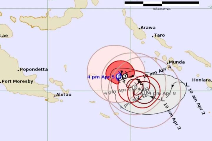
Bureau of Meteorology charts sketch the system’s anticipated footprint from Hunter to Illawarra, with Port Macquarie through the Illawarra facing strongest impacts. Wind instruments may register gusts near 90 km/h between Friday night and Sunday.
Wave buoys will likely record significant heights of 3-4 meters, potentially reaching up to 5 meters in exposed northern coastal waters by Sunday. Beach-goers who recall the storm surges of decades past know to avoid these swells, which reshape our shorelines through natural but sometimes destructive processes.
Soil moisture probes tell a concerning story. Catchments remain saturated following May’s deluge. The floodplain maps once drawn by hand now digitized and precise, highlight vulnerable zones where waters rise fastest.
“Catchments are still wet from recent weather events and may respond quickly to rainfall. Flash flooding and renewed river rises are possible with the forecast rainfall,” notes Nicole Hogan from NSW SES, speaking in practical terms any long-time rural resident understands.
The flood gauges, once simple staff measurements painted on bridge pylons, now form complex telemetry networks. These instruments stand ready to capture rising waters across multiple catchments, particularly along central and southern coasts.
Our changing climate adds further complexity. Weather systems that once appeared predictable now show new behaviors. East Coast Lows are projected to become rarer in winter, with coastal impacts amplified by higher sea levels, disrupting seasonal patterns once reliable enough to plan harvests and fishing seasons.
The economic toll adds up. Flooding costs NSW around $250 million yearly according to government calculations, figures that dwarf the modest disaster relief funds of previous decades. Insurance challenges mount for repeatedly flooded properties, a problem not faced by previous generations when coverage remained broadly available.
For local councils, coastal erosion threatens infrastructure planned and built under different climate assumptions. Drainage systems designed for yesterday’s rainfall patterns strain under today’s intensities.
Traditional knowledge once guided communities through weather extremes. First Nations practices regarding waterway management and landscape resilience offer insights increasingly valued by emergency planners. These approaches, sidelined for generations, now inform community preparation alongside modern forecasting.
Tourism operators from Byron to Batemans Bay monitor these forecasts closely. Weekend beach plans face cancellation; regional agriculture watches with concern as forecast conditions approach.
For residents in flood-prone areas, preparation means clearing gutters and securing loose items—simple actions still effective after generations of storm experience. Digital tools like the Hazards Near Me app provide warnings that once came through radio bulletins and telephone trees.
The weekend’s heavy rainfall will eventually ease as the low drifts eastward into the Tasman, though powerful surf conditions may linger. Seasonal outlooks suggest above-average rainfall through early spring, continuing a wetter pattern across eastern NSW.
As rain clouds gather, communities prepare with knowledge accumulated through generations of storms, enhanced by new tools but guided by timeless wisdom: respect water’s power, protect your property, check on neighbors. Some lessons never change, even as our climate does.
Frequently Asked Questions
What is a coastal low?
A coastal low is a weather system that forms over the ocean and brings heavy rain and strong winds to nearby shores.
When will the rain and wind arrive?
The rain starts Friday night, with peak showers and gusts between Saturday morning and Sunday afternoon.
How much rain and wind should I expect?
Most areas will see 50–100 mm of rain and winds up to 90 km/h in exposed spots.
Could my street flood?
With catchments already wet, low-lying roads and floodplains may see short-term rises. Check local flood maps.
How can I prepare my home and family?
Clear gutters, secure loose items, review your emergency kit, and plan safe routes away from floodwaters.
Which areas are most at risk?
The Hunter, Central Coast, Sydney and Illawarra regions face the highest rainfall and wind gusts.
What alerts should I use?
Download the “Hazards Near Me” app, set your watch zone, and enable SES warnings by SMS or email.
What should I avoid during the storm?
Never drive through floodwater, stay away from beaches during high surf, and avoid standing under trees in high winds.
Test Your Storm Prep Knowledge
1. How much rain is expected this weekend?
See answer
Answer: 50–100 mm, with isolated spots up to 120 mm.
2. What wind gust speed could be reached?
See answer
Answer: Up to 90 km/h along exposed coastal fringes.
3. Which app helps you get real-time SES alerts?
See answer
Answer: Hazards Near Me.
4. True or False: It’s safe to drive through shallow floodwater.
See answer
Answer: False. Even shallow water can sweep a car away.