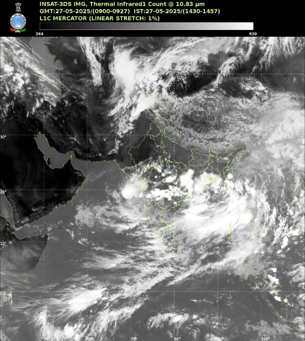
Kerala’s coconut palms swayed under gathering storm clouds on May 24, 2025—eight days ahead of schedule. The onset of the southwest monsoon over Kerala on May 24 is its earliest onset since May 23, 2009, marking a rare meteorological event that sent ripples of both excitement and concern across India’s agricultural heartland.
This wasn’t just another weather update. The southwest monsoon—India’s annual lifeline that delivers nearly 70% of the rain that India needs to water farms and replenish aquifers and reservoirs—had arrived with unusual vigor. Behind this early arrival lay a fascinating atmospheric ballet involving ocean temperatures, wind patterns, and pressure systems stretching from Madagascar to the Pacific.
Understanding Monsoon’s Green Signal
The India Meteorological Department (IMD) doesn’t simply declare monsoon onset when the first raindrop falls. If after 10th May, 60% of the available 14 stations enlisted*, viz. Minicoy, Amini, Thiruvananthapuram, Punalur, Kollam, Allapuzha, Kottayam, Kochi, Thrissur, Kozhikode, Thalassery, Kannur, Kudulu and Mangalore report rainfall of 2.5 mm or more for two consecutive days, the onset can be declared—but only if two other conditions align.
The zonal wind speed over the area bounded by Lat. 5-10ºN, Long. 70-80ºE should be of the order of 15 – 20 Kts. at 925 hPa, and crucially, INSAT derived OLR value should be below 200 wm-2 in the box confined by Lat. 5-10°N and 70-80°E. This triple-lock system ensures that what IMD declares as monsoon onset truly represents the seasonal wind reversal, not just a passing weather system.
The Ocean-Atmosphere Symphony
Madden-Julian Oscillation: The Wandering Wave
Picture a massive pulse of thunderstorms and rain, slowly journeying eastward around Earth’s equator every 30-60 days. This is the Madden-Julian Oscillation (MJO), and in May 2025, it played a starring role in the monsoon’s early arrival.
The 22 May ECMM extended-range outlook indicated the MJO in Phase 4 (amplitude ≈ 1), shifting into Phase 5 (amplitude > 1) by late week 1—phases known to enhance convection over the south Bay of Bengal and Arabian Sea corridor. When the MJO reaches these phases, it essentially opens the atmospheric floodgates over the Indian Ocean, creating conditions ripe for monsoon advancement.
When it is over the Indian Ocean during the Monsoon season, it brings good rainfall over the Indian subcontinent. The 2025 event showcased textbook MJO behavior—its relatively short cycle providing multiple visits to the Indian Ocean region during the critical onset period.
Mascarene High: The Southern Powerhouse
Far south in the Indian Ocean, between 20°S and 35°S, near the Mascarene Islands, sits a semi-permanent high-pressure system that acts like a giant atmospheric pump. A stronger high pressure will produce stronger winds or monsoon current, and in 2025, this system flexed its muscles early.
The Mascarene High creates the crucial pressure gradient between the southern Indian Ocean and the heated Indian subcontinent. This gradient drives the cross-equatorial winds that eventually become the moisture-laden southwest monsoon. Recent research shows concerning trends—increased sea level and heat content in the MH region during the GWH (1998-2016) suppressed the intensity of low-level cross-equatorial winds. However, the 2025 season bucked this trend with a robust high-pressure system.
Somali Jet: The Moisture Highway
When cross-equatorial winds accelerate along the East African coast, they create one of the world’s most powerful low-level wind systems—the Somali Jet. Named after the Somali coast where it reaches peak intensity, this atmospheric river can exceed speeds of 80 kilometers per hour at its core.
This jet descends over the Indian Ocean (near Madagascar) and intensifies its high pressure cell so as to move as south-west monsoon. The jet acts as a conveyor belt, transporting massive amounts of moisture from the southern Indian Ocean into the Arabian Sea and eventually over the Indian subcontinent.
Arabian Sea Heat Low: The Suction Engine
As pre-monsoon heat builds over Pakistan and northwest India, it creates an intense thermal low-pressure system. This “heat low” acts like a giant vacuum cleaner, sucking in the moisture-laden winds from the ocean. Convergence is solely responsible for the spinup and maintenance of the primary heat low circulation.
The strength and position of this heat low directly influence how quickly and powerfully the monsoon advances. In 2025, early season heating created a deeper-than-normal low, enhancing the pressure gradient and accelerating monsoon onset.
Bay of Bengal: The Warm Water Catalyst
While the Arabian Sea components set the stage, the Bay of Bengal provided the spark. IMD’s RSMC bulletin (24 May) reports Bay of Bengal SSTs at 30 °C–32 °C—among the highest on record for late May—fostering intense convection and lowering surface pressures ahead of the monsoon wave.
These exceptionally warm waters—typically found only at the peak of summer—created a breeding ground for the low-pressure systems that help pull the monsoon northward. Tropical cyclones form over warm waters, when the temperature is more than 27°C. Whether it’s pre-monsoon or post-monsoon, Bay of Bengal’s SST is around 29°C or 30°C.
The Missing Pieces: ENSO and IOD
Unlike dramatic El Niño or La Niña years, 2025’s monsoon arrived during remarkably neutral conditions in both the Pacific and Indian Oceans. As of mid-April 2025, sea-surface-temperature (SST) anomalies in the Niño 3.4 region were nearly zero, and the International Research Institute’s multimodel ENSO plume showed a 96 % probability of ENSO-neutral conditions continuing through June 2025.
Similar Posts
Similarly, the Indian Ocean Dipole index was neutral and projected to remain so through the season, meaning no anomalous east–west SST gradient impeded monsoon moisture transport. This neutrality actually favored the monsoon—without competing climate patterns to disrupt the flow, the regional drivers could operate at full strength.
Below-normal snow cover across Eurasia over the past three months has reduced albedo and strengthened the Arabian heat-low, thus enhancing the meridional pressure gradient that “pulls” the monsoon trough southward. This often-overlooked factor played a crucial supporting role in 2025’s early onset.
Historical Echoes and Future Warnings
The 2025 onset joins an exclusive club. The earliest recorded monsoon onset in Kerala was on May 11, 1918, while the most delayed was on 18 June in 1972. The 2009 onset on May 23 was the most recent early arrival before this year. In 1971, monsoon at the time of onset covered a larger area in Karnataka and parts of Maharashtra, according to M. Rajeevan, former Secretary at the Ministry of Earth Sciences.
However, early onset doesn’t guarantee smooth sailing. In 2024, after an early and a rare simultaneous onset of monsoon over Kerala and the Northeastern states, the Bay of Bengal branch of the monsoon stalled for at least 19 days due to Cyclone Remal. A similar scenario unfolded in 2021 when Cyclone Tauktae in the Arabian Sea and Cyclone Yaas in the Bay of Bengal made the monsoon stall for 24 days.
The Twin Cyclone Threat
As of May 26, 2025, meteorologists watch nervously as twin cyclonic systems in the Arabian Sea and the Bay of Bengal threaten to disrupt the monsoon’s northward march. “As usual, a cyclone can pull the monsoon trough forward and favour an early onset depending on its location,” Raghu Murtugudde, professor of climate studies at the Indian Institute of Technology, Bombay and emeritus professor at the University of Maryland, told Down To Earth.
These twin systems create a meteorological tug-of-war, potentially stalling the monsoon trough between them. Press Release: extremely heavy rainfall over Kerala, Konkan including Mumbai city, ghat areas of Madhya Maharashtra, Coastal and Ghat areas of Karnataka on 26th & 27th; Ghat areas of Tamil Nadu on 26th May, 2025 warned IMD, indicating the immediate impacts of these systems.
Agricultural Implications and Water Security
Early monsoon rains will encourage farmers in India, the world’s largest rice exporter, to start planting earlier. For regions like Maharashtra, which received the monsoon on May 20, 1990 during the last comparable early onset, the advancement means crucial extra weeks for Kharif crop establishment.
However, the blessing comes with caveats. Pre-monsoon rains harming summer crops and Marathwada’s 1,030% rainfall anomaly demonstrated how timing mismatches can damage standing crops awaiting harvest.
Water managers face their own challenges. Early onset means earlier reservoir filling, but also requires careful management to avoid premature releases if the monsoon stalls mid-season. Urban areas must prepare for extended monsoon impacts—Mumbai’s flooding risk period effectively extended by 10 days.
Climate Change Fingerprints
The 2025 early onset fits within a pattern of increasing monsoon variability. The accelerated trend of the heatwave days is found to be driven by the rapid rise in the mean sea surface temperature (SST) of the Arabian Sea in the recent decade. This warming creates conditions conducive to both extreme heat events and sudden monsoon bursts.
WMO’s Global Seasonal Climate Update notes that rising background temperatures are intensifying monsoon variability—leading to both early pulses and prolonged breaks. The 2025 event exemplifies this new normal of extremes.
Tomorrow’s Scene: A Season of Uncertainty
Despite the dramatic early start, “There is no direct correlation between the onset date and the total rainfall over the country during the season,” an IMD official explained. The season’s ultimate character depends on multiple factors still evolving.
“Forecast indicates that neutral El Niño–Southern Oscillation (ENSO) conditions are likely to continue during the monsoon season.” The IMD has also predicted neutral Indian Ocean Dipole (IOD) conditions during the upcoming southwest monsoon season. With Above normal rainfall is most likely during the 2025 southwest monsoon season (June – September) over most parts of the South Asia, farmers and water managers can cautiously plan for a favorable season.
The Science of Tomorrow’s Rain
As Kerala’s farmers watch their fields green under early monsoon showers, atmospheric scientists continue monitoring the delicate balance of forces that brought this bounty. The convergence of favorable MJO phasing, robust cross-equatorial flow, exceptional Bay of Bengal warmth, and neutral ENSO-IOD conditions created a “perfect storm” for early onset.
Understanding these mechanisms isn’t just academic exercise—it’s crucial for the billion-plus people whose lives sync with the monsoon’s rhythms. Each early onset, each stalling event, each anomaly adds another piece to the climate puzzle that scientists race to solve as our planet warms.

The 2025 southwest monsoon has announced itself with authority. Whether it maintains this momentum or stumbles like its predecessors remains to be written in the clouds gathering over the Arabian Sea and Bay of Bengal. For now, India welcomes the rain, eight days early but right on time for a nation always waiting for the monsoon’s promise of renewal.
The India Meteorological Department declared the Southwest Monsoon onset over Kerala on May 24, 2025, eight days ahead of the normal June 1 date. This early arrival was attributed to several meteorological factors including the Madden-Julian Oscillation in a favorable phase, the Mascarene High pressure system, enhanced convective activity, the Somali Jet, and favorable sea surface temperature conditions. The IMD applied specific criteria involving rainfall measurements at designated stations, wind field characteristics at specified altitudes, and satellite-derived Outgoing Longwave Radiation values for the onset declaration. The monsoon subsequently advanced to additional regions including parts of Karnataka, Goa, Maharashtra, and northeastern states by May 25. The IMD forecast above-normal rainfall for the 2025 season while ruling out El Niño conditions. Agricultural implications, water resource management considerations, and historical context of monsoon onset variability were noted in relation to this early arrival.
