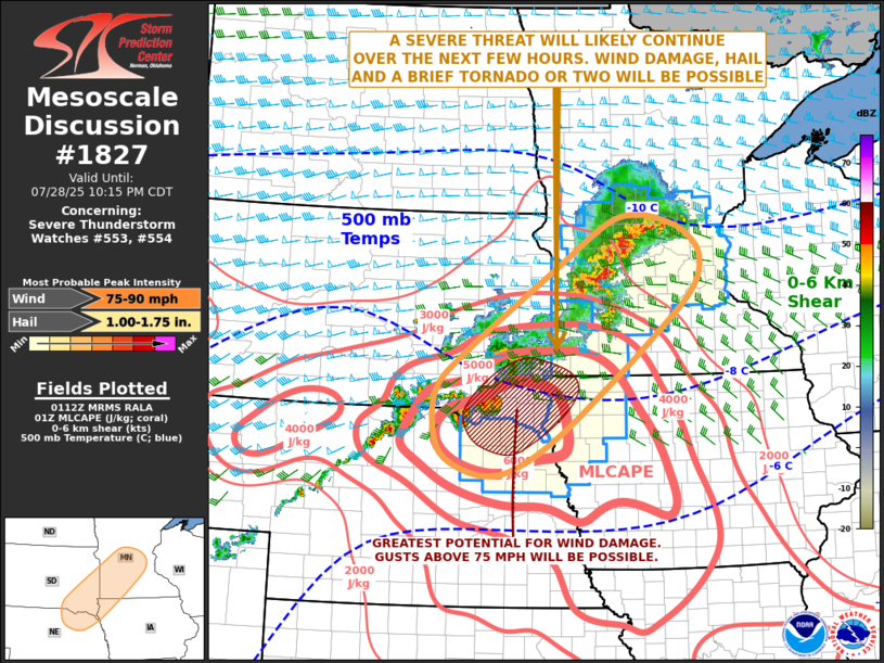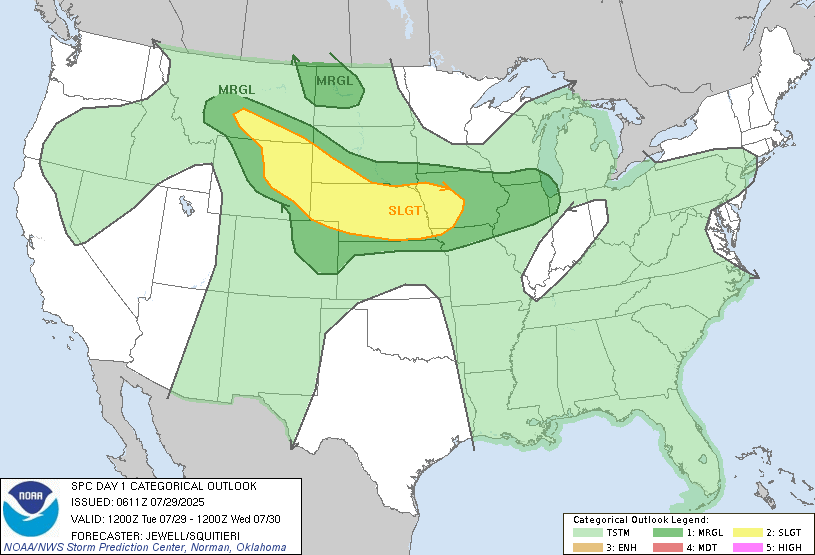
Powerful thunderstorms packing 70+ mph winds are marching toward southeast Minnesota and southern Wisconsin tonight, with the Storm Prediction Center placing most of the region under Slight (Level 2) or Marginal (Level 1) risk zones.
The National Weather Service has issued a Severe Thunderstorm Watch valid from 10:05 p.m. CDT July 28 until 4:00 a.m. CDT July 29 for Rochester (NWS ID KRST) and surrounding areas.
The primary threat from these nocturnal storms will be damaging straight-line winds, with the greatest risk being damaging winds in excess of 75 mph. Isolated tornadoes remain possible but the risk is lower than the wind threat.
Storm timing places the system along I-35 by 10-11 p.m., moving eastward toward Highway 52 between 11 p.m. and 1 a.m. This timeline may shift as storms develop, so residents should stay alert throughout the night.
🌩️ Are You Storm‑Ready?

Heavy rainfall between three quarters and one inch is expected, which could create urban flooding issues on already saturated soils. The NWS Aberdeen office warns of minor river flooding, with a Flood Warning in effect for the Minnesota River at Montevideo.
The storms arrive amid ongoing heat concerns, with daytime temperatures having reached dangerous levels. A cold front will clear the storms by mid-morning Tuesday, bringing cooler, drier air later in the week.
How to Stay Safe Tonight
Have multiple ways to receive weather alerts overnight:
- NOAA Weather Radio: 162.550 MHz (Rochester)
- FEMA smartphone app
- County emergency text alerts (sign up at publicalert.mn.gov)
KTTC meteorologists recommend keeping devices charged and preparing for possible power interruptions.
Before storms arrive:
- Secure loose outdoor items
- Trim weak tree branches
- Have flashlights and battery banks ready
- Identify a safe interior room or basement
During storms, stay in interior rooms on the lowest level, away from windows. In basements, watch for rising water and move to higher ground if flooding occurs.
Previous nocturnal thunderstorm events have brought 80 mph gusts across southeast Minnesota, causing widespread power outages.
Residents can track live updates from the National Weather Service at weather.gov.