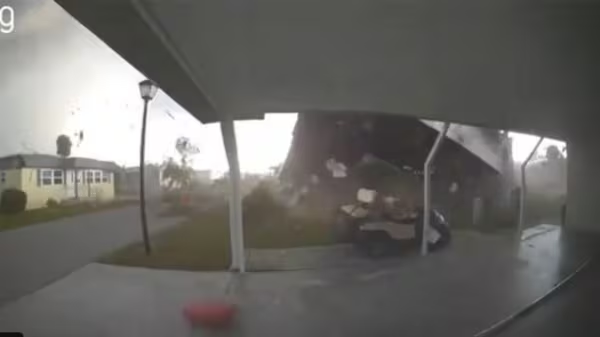
A powerful tornado tore through parts of Pinellas County on Wednesday evening, damaging dozens of homes and leaving a trail of destruction across Largo and Pinellas Park neighborhoods.
The severe weather struck around 7:20 PM on June 25, primarily impacting mobile home communities and causing significant property damage, though remarkably, no injuries or fatalities have been reported so far.
The National Weather Service (NWS) in Tampa Bay has scheduled a damage survey for Thursday to officially determine the tornado’s strength on the Enhanced Fujita (EF) scale, which measures tornado intensity based on damage patterns. Local reports from Bay News 9 confirm the tornado touched down in Largo, where approximately 20 roofs were torn off homes in the Ranchero Village mobile home community.
“Houses are destroyed, and people are devastated just walking around, just in shock,” said one resident quoted by local media. Dramatic video footage captured by witnesses showed mobile homes being lifted, flipped, and dropped as debris swirled through the air.
The tornado’s path cut through densely populated areas, including the Ranchero Village and Bay Ranch Manufactured Home Communities off Ulmerton Road in Largo. The destruction continued south through areas off Belcher Road, down to Brian Dairy Road, and into the Pinebrook neighborhood in Pinellas Park. Power outages affected over 6,000 customers in Pinellas County, with utility crews working through the night to restore service.Local authorities responded swiftly to the emergency. The Largo Police Department, Largo Fire Rescue, Pinellas Park Police Department, Fire Department, and Public Works were all dispatched to the affected areas. Their immediate priority was ensuring resident safety, assessing damage, and clearing roadways of downed trees and power lines. Officials urged the public to avoid damaged zones to allow emergency crews to work efficiently.
Similar Posts:
This tornado occurred during what meteorologists had predicted would be an above-normal 2025 Atlantic hurricane season. While Florida experiences tornadoes year-round, they often increase during summer months, particularly in June. According to the Florida Climate Center, June typically sees the highest frequency of tornadoes in the state, which has the highest concentration of tornadoes per 10,000 square miles in the nation.
What makes this tornado particularly notable is that it formed without a tornado watch being in effect. The area was under a severe thunderstorm warning, but the twister developed rapidly amid a stalled upper-level low interacting with sea breeze fronts – weather conditions characteristic of early summer in Florida.
The storm system that spawned the tornado also produced hail ranging from pea to quarter-sized in the region, highlighting the instability in the atmosphere. This type of severe weather serves as a reminder that Florida residents should stay vigilant and prepared for rapidly developing storms, even when specific tornado watches aren’t issued.

As the NWS conducts its official damage assessment today, more details about the tornado’s strength, path length, and width will emerge. For now, the focus remains on supporting affected residents and beginning the cleanup process across the damaged communities in Pinellas County.
The tornado comes just days after Tropical Storm Andrea formed in the Atlantic on June 24, becoming the first named storm of the 2025 hurricane season. While Andrea posed no threat to Florida before dissipating, its formation signals the official start to what NOAA has predicted will be an above-normal season with 13-19 named storms expected.