A powerful storm system is rapidly forming off Australia’s east coast and will hit between Monday, June 30 and Thursday, July 3, 2025. Weather experts call this fast-developing system a “w eather bomb” because it’s experiencing a dramatic pressure drop in just 24 hours.
The Bureau of Meteorology (BoM) warns this could become the first East Coast Low (ECL) in three years. Unlike the misleading term “rain bomb” often used in headlines, this is a genuine “bomb cyclone” – the pressure will drop 22-24 hectopascals within a day, meeting scientific criteria for such classification.
“It’s really a couple of days of quite persistent rainfall for central and southern parts of NSW as well as the east of Victoria,” said BoM meteorologist Angus Hines, who described the system as set to “drench and batter” affected regions.
The heaviest impacts will hit New South Wales, especially areas between the Mid North Coast and Illawarra, though effects will reach into eastern Victoria and southeast Queensland. Rain will begin Monday, intensify Tuesday, and reach peak strength Wednesday.
Residents should prepare for three main threats:
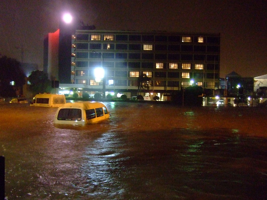
Heavy rainfall: Most coastal areas will see 100-200mm over a day and a half, with some spots potentially receiving over 300mm where rain hits mountains or hills. This much rain creates serious flash flooding risks and will cause rivers to rise rapidly.
Damaging winds: Gusts between 90-100 km/h will hit coastal areas, especially between Coffs Harbour and Jervis Bay. These strong winds can knock down trees in rain-soaked soil and cause power outages.
Similar Posts
Dangerous surf: Large waves measuring 5-6 meters high (with maximum waves possibly reaching 11-13 meters) will pound the coastline. These powerful easterly swells threaten to cause serious beach erosion at vulnerable spots like Collaroy Beach in Sydney and Wamberal Beach on the Central Coast.
What makes this storm particularly dangerous is the unusually warm Tasman Sea, currently measuring 2-2.5°C above normal June temperatures. This warm water feeds energy and moisture into the developing storm system.
The BoM has already issued flood watches for several river systems including the Hawkesbury-Nepean, Georges, Cooks, and coastal catchments.

If you live in these areas:
- Secure outdoor furniture and items that could blow away
- Prepare emergency supplies of food, water, and medications
- Never drive through flooded roads – even shallow water can be dangerous
- Stay informed through the BoM website and app
- Follow directions from emergency services
While East Coast Lows typically occur several times each year, most frequently in June, this system’s rapid development and the warm ocean temperatures make it particularly concerning. Conditions should gradually improve after Thursday.