A severe thunderstorm watch for north-central Iowa was canceled at 12:00 a.m. CDT—two hours before its scheduled 4 a.m. expiration—while warnings remain in effect for northeast counties. The powerful line of storms tracked east of Interstate 35 and north of US 30 by 12:45 a.m., leaving thousands without power and causing significant damage across multiple counties.
Fierce Winds Flip Campers, Snap Power Poles
At the Ventura campground, multiple campers were blown over by intense straight-line winds, according to Cerro Gordo Emergency Management. The Spencer Airport weather station recorded a 92 mph gust at 10:42 p.m., equivalent to a Category 1 hurricane on the Saffir-Simpson scale.
MidAmerican Energy reports approximately 32,700 customers impacted statewide, with concentrated outages of about 11,000 around Storm Lake and 2,000 around Fort Dodge. Rural electric cooperatives reported an additional 1,200 customers without service. Utility crews aim to restore most power by 5 p.m. today.
Counties Under Warning
Multiple counties faced severe thunderstorm warnings overnight:
- Hardin, Webster, Wright, Franklin, Humboldt, Hamilton, Story, Greene, Calhoun, Carroll, and Boone until 12:30 a.m.
- Emmet, Worth, Kossuth, Hancock, Cerro Gordo, Winnebago, and Palo Alto until 12:30 a.m.
Similar Posts
What Makes This a Potential Derecho?
Monday night’s storm system shares characteristics with derechos—long-lived, fast-moving thunderstorm complexes capable of widespread destruction. According to NOAA/ECCC criteria updated in January 2022, derechos must:
- Produce a wind damage swath at least 400 miles long
- Feature gusts of 58+ mph along most of the swath
- Include at least 3 gusts of 75+ mph separated by 80+ miles
- Maintain duration of at least 3 hours
“These systems move at speeds of 50 mph or greater, giving little visual warning,” notes Russ Schumacher, meteorologist at Colorado State University. “The instability at the boundary between hot, humid air and cooler regions fuels these intense, long-lived convective systems.”
Iowa has experienced two major derechos in recent years. The July 11, 2011 event produced 100+ mph winds in Cedar Rapids, while the August 10, 2020 derecho—spanning from Nebraska to Indiana—generated 140 mph winds near Cedar Rapids and caused $11.2 billion in damage, making it the costliest thunderstorm event in U.S. history.
Road Conditions and Safety
The Iowa Department of Transportation advises travelers to monitor road conditions via 511ia.org.
If your power is out, food safety becomes critical. The FDA advises:
- Refrigerators will keep food safe for about 4 hours without power
- Full freezers maintain temperature for approximately 48 hours (24 hours if half-full)
- Keep refrigerator and freezer doors closed as much as possible
Tonight’s Forecast
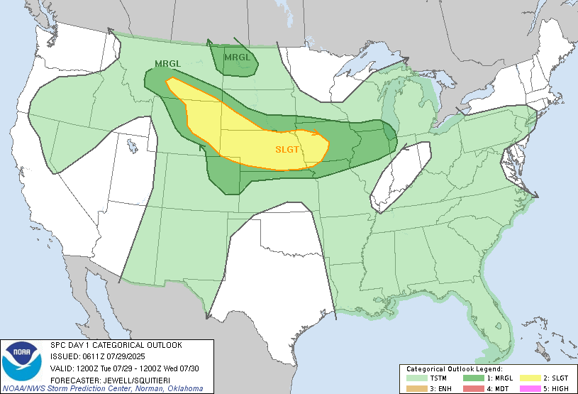
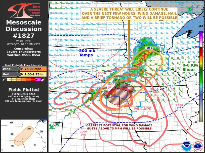
Northern Iowa has been upgraded to a Level 4 (of 5) risk for severe weather tonight. The Storm Prediction Center warns of potential 90 mph wind gusts and brief tornadoes. According to the National Weather Service Des Moines forecast discussion, the current line of severe storms should exit the area by 3-4 a.m. CDT.

Additional storms are expected Tuesday night (50% chance) with humid overnight lows of 65-70°F. Wednesday will bring highs of 73-76°F with scattered storms.
For the latest updates, monitor NOAA Weather Radio, check the Iowa Association of Electric Cooperatives outage map (updated every 15 minutes at iowarec.org/outages), and keep weather alert apps enabled on your devices.