As of 5:00 AM MST Wednesday, Hurricane Lorena sits 105 miles southwest of Cabo San Lucas, Mexico, with maximum sustained winds of 75 mph. The storm moves northwest at 15 mph and is forecast to continue strengthening through Wednesday evening before fast weakening begins Thursday.
Lorena’s center will track parallel to Baja California’s west coast through Wednesday night, then approach the peninsula late Thursday through Friday. The National Hurricane Center expects the storm to weaken to tropical storm status by Friday.

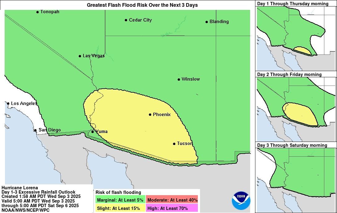
The most serious concern centers on catastrophic rainfall totals. Baja California Sur faces 5 to 10 inches of rain, with isolated areas receiving up to 15 inches through Friday. This rainfall creates life-threatening flash flood and mudslide risks, especially in mountainous terrain.
For the U.S. Southwest, Arizona can expect 1 to 3 inches of rain with localized totals up to 4 inches through Friday, bringing isolated to scattered flash flooding potential. Weather models show uncertainty about the exact moisture distribution, but AccuWeather lead hurricane expert Alex DaSilva warns that if the storm moves inland as forecast, “heavy rain can spread across southern Arizona, southern New Mexico and even into western Texas”.
Mexico has issued extensive coastal warnings. A Tropical Storm Warning covers Baja California Sur’s west coast from Santa Fe to Punta Abreojos, with tropical storm conditions expected beginning Wednesday night. Tropical Storm Watches extend from Cabo San Lucas northward to Santa Fe, and from north of Punta Abreojos to Punta Eugenia.
The National Weather Service Weather Prediction Center has issued flood outlook products for the Southwest. Local TV meteorologists in Phoenix have declared two consecutive First Alert Weather Days for Thursday and Friday, with storm chances near 40% Thursday daytime and 60% for evening hours.
Arizona remains entirely under drought conditions while 70% of New Mexico suffers from drought. This creates a complex scenario where beneficial rainfall could quickly turn dangerous due to hardened soil and flash flood risks in desert washes.
Hurricane-force winds extend outward 10 miles from Lorena’s center, with tropical storm-force winds reaching 60 miles outward. Dangerous surf and life-threatening rip currents will affect Baja California Sur’s south and west coasts through Friday.
Track uncertainty remains significant for Lorena’s eventual path and intensity. Weather Prediction Center meteorologists note disagreement between forecast models, with some showing the storm’s low-level center weakening offshore while others suggest inland movement into northwest Mexico. This track difference determines rainfall distribution across Arizona and New Mexico.
According to local NWS forecasts, storm chances drop to 20% Saturday as dry air returns, leading to temperature rebounds reaching 100 degrees by Sunday. The National Hurricane Center continues monitoring and will issue the next complete advisory at 8:00 AM MST Wednesday.Hurricane Lorena marks the 12th named storm of the 2025 Eastern Pacific hurricane season. The storm’s remnant moisture and upper-level circulation are expected to influence Southwest weather patterns through the weekend, with the greatest flash flood potential Thursday through Friday across southern Arizona and southwestern New Mexico.