Cyclone Montha Makes Landfall: Tracking the Severe Storm’s Path Across India’s Eastern Coast
Real-time tracking of wind speeds up to 110 km/h, extensive flooding across Andhra Pradesh and Odisha, and coordinated emergency response as the storm weakens inland
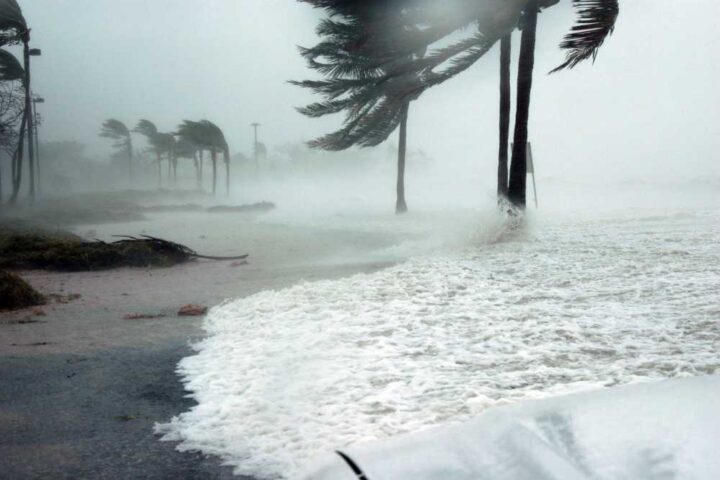
Severe Cyclonic Storm Montha crossed the Andhra Pradesh and Yanam coasts between Machilipatnam and Kalingapatnam, south of Kakinada, close to Narsapur near latitude 16.35°N and longitude 81.65°E during midnight hours of October 28-29, 2025. The India Meteorological Department confirmed the landfall process commenced around 17:30 IST on October 28, continuing for approximately 3-4 hours with maximum sustained wind speeds of 90-100 km/h gusting to 110 km/h.
The cyclone formed from a well-marked low-pressure area over the southeast Bay of Bengal around October 24, 2025, according to IMD bulletins. By October 26, it intensified into a deep depression, and by the morning of October 28, it had strengthened into a severe cyclonic storm. The system moved north-northwestwards at speeds between 12-17 km/h during its approach to the coast, with wind speeds recorded at 68 km/h in Machilipatnam, 52 km/h in Kakinada, and 50 km/h at Rajahmundry Airport during landfall.
Named “Montha” by Thailand—meaning “fragrant flower” in Thai—the cyclone brought extremely heavy rainfall (≥21 cm) at isolated places over Coastal Andhra Pradesh and Yanam on October 28. India’s monsoon patterns have shown increasing intensity in recent years, with this storm adding to the challenges faced by eastern coastal regions.
Impact at a Glance
The cyclone impacted 403 mandals across 22 districts of Andhra Pradesh, with the state government establishing 488 control rooms at the mandal level for coordinated response. Approximately 40 lakh people remained in vulnerable zones during the storm’s passage, prompting large-scale evacuations and emergency measures. Union Railway Minister Ashwini Vaishnaw reviewed preparedness with East Coast Railway and South Central Railway zones to minimize passenger inconvenience and ensure quick restoration of services.
The National Disaster Response Force (NDRF), known for its rapid response capabilities, deployed teams strategically across the impact corridor. Of the 26 teams mobilized, 12 were stationed in Andhra Pradesh—the area expected to experience the most severe impact—6 in Odisha, and 3 in northern Tamil Nadu, with additional personnel in Telangana and Chhattisgarh for support operations.
Cyclone Montha’s Path & Regional Impact
Track the cyclone’s journey from formation in the Bay of Bengal to landfall near Kakinada, Andhra Pradesh, showing the storm’s movement through affected regions and key monitoring stations
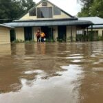
Storm surge of approximately 1 metre above astronomical tide was expected along the coast, inundating low-lying areas. High tidal waves damaged the 8-km Uppada-Kakinada beach road, forcing authorities to close it for traffic. Great danger signal number 10—the highest danger signal issued to ports during severe cyclones—was hoisted at Kakinada Port, while great danger signal 9 was raised at Visakhapatnam, Gangavaram, Kalingapatnam, and Bheemunipatnam ports.
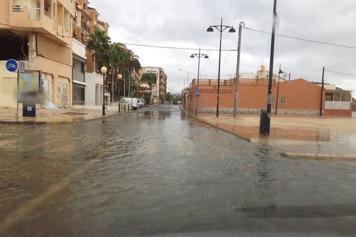
Under the influence of the severe cyclonic storm, Nellore district in Andhra Pradesh recorded the highest amount of rainfall during the 24-hour period ending at 08:30 IST on October 28. Heavy to very heavy rainfall (7-20 cm) was recorded at isolated places over East Rajasthan, Gujarat State, and West Madhya Pradesh, while heavy rainfall (7-11 cm) was observed at isolated places over Rayalaseema, Kerala & Mahe, Odisha, Chhattisgarh, East Madhya Pradesh, Madhya Maharashtra, and Tamil Nadu.

24-Hour Timeline: Cyclone Montha’s Evolution
Hourly tracking from intensification to landfall and weakening, based on official IMD bulletins
Montha intensified into a severe cyclonic storm positioned 190 km south-southeast of Machilipatnam with maximum sustained winds of 90-100 km/h gusting to 110 km/h.
Landfall process commenced. The storm was 110 km south of Kakinada as it began crossing the Andhra Pradesh coast. Latest observations indicated the cyclone would make full landfall within 3-4 hours.
Cyclone Montha crossed the coast between Machilipatnam and Kalingapatnam, south of Kakinada, close to Narsapur at latitude 16.35°N and longitude 81.65°E during midnight hours.
The severe cyclonic storm weakened into a cyclonic storm over coastal Andhra Pradesh, positioned 20 km west-northwest of Narsapur, moving northwestwards at 10 km/h. The rear sector of the storm entered inland.
Further weakened into a deep depression over Coastal Andhra Pradesh and adjoining Telangana, centered 50 km south-southeast of Bhadrachalam. Expected to weaken to a depression within next 6 hours.
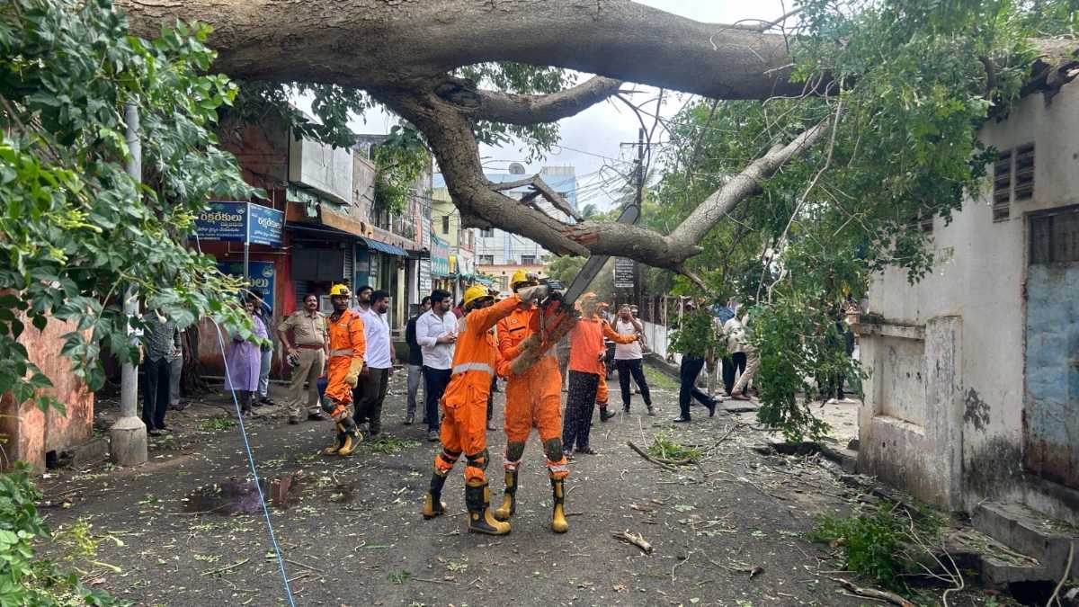
Tragically, one woman died at Makanagudem village in Konaseema district when an uprooted palmyra tree fell on her during strong winds. The incident occurred as gale-force winds swept through the coastal districts during the landfall process. This fatality occurred despite extensive evacuation efforts and precautionary measures taken by authorities across vulnerable areas.
Transportation networks faced severe disruptions. South Central Railway cancelled 122 trains, with around 183 trains in total affected through cancellations, diversions, and rescheduling. Most affected services operated between the Visakhapatnam and Vijayawada sections. Over 35 flights between Shamshabad in Telangana and Vijayawada, Visakhapatnam, and Rajahmundry airports in Andhra Pradesh were cancelled, including 30 IndiGo, 2 Air India, and 5 Air India Express flights.
Regional Impact Assessment
Detailed breakdown of damage and affected areas across multiple states based on official reports
Agriculture
Extensive agricultural damage across Andhra Pradesh with 38,000 hectares of standing crops destroyed and 1.38 lakh hectares of horticulture crops affected, according to preliminary estimates from the Chief Minister’s Office. Rice, cotton, and vegetable crops bore the brunt of heavy rainfall and strong winds.
Transportation
South Central Railway cancelled 183 trains with 122 cancellations, multiple diversions, and rescheduling affecting services between Visakhapatnam and Vijayawada sections. Over 35 flights cancelled at Shamshabad, Vijayawada, and Visakhapatnam airports.
Coastal Areas
High tidal waves damaged the 8-km Uppada-Kakinada beach road. Storm surge of approximately 1 metre above astronomical tide inundated low-lying coastal areas. Authorities restricted public access to beaches and coastal roads as precautionary measures, similar to responses during Cyclone Fengal.
Rainfall
Extremely heavy rainfall (≥21 cm) recorded at isolated places over Coastal Andhra Pradesh and Yanam. Nellore district recorded the highest rainfall during the 24-hour period ending at 08:30 IST on October 28. Heavy to very heavy rain continued across Telangana, Chhattisgarh, and Odisha.
Infrastructure
Trees uprooted across multiple districts causing power outages. Roads inundated with waterlogging reported in urban areas including Vijayawada. The Department of Telecommunications maintained 81 wireless towers and 21 large lamps for emergency communication throughout the crisis.
Human Impact
One fatality reported in Konaseema district when an uprooted palmyra tree fell. 76,000 people evacuated to 1,906 relief camps. Approximately 40 lakh people across 19 districts remained in vulnerable zones during the storm’s passage, requiring coordinated disaster management response.
Odisha Chief Minister Mohan Charan Majhi reviewed the situation at the State Disaster Management Authority (SDMA) control room and reported that Odisha escaped major damage from Cyclone Montha, bringing relief to the state even as precautionary measures remained in force. Only minor landslides and tree uprooting were reported in some areas, with preliminary damage reports received from eight southern Odisha districts: Malkangiri, Koraput, Rayagada, Gajapati, Ganjam, Kandhamal, Kalahandi, and Nabarangpur.
The Union Health Ministry reviewed preparedness measures for Cyclone Montha with senior officials of the eastern coastal states, including Andhra Pradesh, Odisha, and Tamil Nadu, extending full support and assuring all necessary assistance for an effective emergency medical response. The coordinated multi-agency approach involved state governments, central agencies, and local authorities working in tandem to minimize casualties and ensure rapid relief operations.
Emergency Response & Preparedness
Coordinated multi-agency response across affected regions with zero-casualty mission
🚨 NDRF Deployment
🏥 Medical Response
🔌 Power Restoration
🚧 Road Clearance
📡 Communication
🍽️ Relief Operations
Current Status & Coverage Summary
Cyclone Montha crossed the Andhra Pradesh coast near Kakinada overnight on October 28-29, 2025, bringing severe weather conditions to coastal regions. The storm has since weakened from a severe cyclonic storm to a deep depression as it moved inland across Andhra Pradesh and Telangana.
The India Meteorological Department continues monitoring the system’s movement, with heavy rainfall warnings remaining in effect for multiple states. The system is being continuously monitored through Doppler Weather Radar (DWR) at Machilipatnam and Visakhapatnam in addition to coastal observatories, automatic weather stations, ships, buoys, and satellites.
Emergency response teams from NDRF, SDRF, and state agencies remain deployed across the affected corridor. Restoration work for power, telecommunications, and transportation infrastructure is underway, with railway services gradually resuming as conditions improve.