Bay Area Earthquake Interactive Experience
Explore the recent Berkeley 4.3 magnitude earthquake and learn how to prepare for future seismic events
Berkeley Earthquake: September 22, 2025
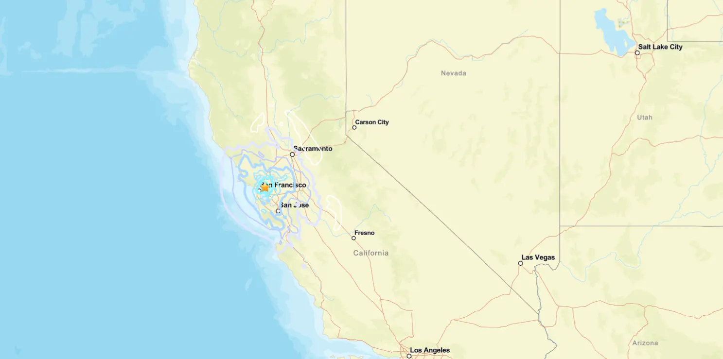
The 4.3 magnitude earthquake’s epicenter was located near the Berkeley-Oakland border, close to the Hayward Fault. This interactive map shows the approximate location and intensity distribution of the earthquake.
About the Hayward Fault
The Hayward Fault is one of the most dangerous faults in the United States, running through the densely populated East Bay. It’s capable of producing earthquakes up to magnitude 7.0. The fault last ruptured in a large earthquake in 1868, and scientists believe it’s due for another significant event.
Experience Different Earthquake Magnitudes
Move the slider to simulate how different magnitude earthquakes might feel. The Berkeley earthquake was a 4.3 on the Richter scale, which typically causes noticeable shaking of indoor items but rarely causes damage.
Magnitude 1.0: Not felt
Detected only by seismographs, not felt by people. About 8,000 earthquakes of this magnitude occur daily worldwide.
Modified Mercalli Intensity Scale
The Modified Mercalli Intensity (MMI) scale describes the effects of an earthquake at different locations. The Berkeley earthquake had intensity levels between III-IV in most areas. Click on each level to learn more about what people experience at different intensities.
Click on an intensity level to learn more about its effects.
Earthquake Preparedness Checklist
Are you prepared for the next earthquake? Use this interactive checklist to ensure you’re ready. Check off items as you complete them to track your progress.
Your Preparedness Progress
Bay Area residents were jolted awake at 2:56:12 a.m. PDT Monday when a 4.3 magnitude earthquake struck near Berkeley, according to the United States Geological Survey (USGS). The tremor, initially reported as 4.6 magnitude before being revised, originated in Berkeley near the Hayward Fault.
Shaking spread across Alameda and Contra Costa counties, with reports from San Francisco, San Leandro, Hayward, Benicia, and Pleasant Hill. The USGS “Did You Feel It?” map showed intensity levels between III-IV on the Modified Mercalli scale—enough to wake sleepers and rattle dishes, but typically not damage structures.
“The building I live in was shaking…. Very scary,” East Bay resident Yevonne Jackmon told KTVU.
Richard Corvin of Oakland described it as “real fast” and noted there were no subsequent jolts.

BART implemented immediate safety protocols, reducing train speeds and conducting system-wide inspections of tracks, tunnels, and stations. This standard procedure following earthquakes caused delays up to about 20 minutes throughout the morning commute.
The San Francisco Fire Department confirmed no injuries or damage within city limits. Emergency services across the region reported no significant earthquake-related incidents.
USGS coordinates placed the epicenter at 37.866°N 122.252°W at a depth of 7.7 kilometers. This location sits along the Hayward Fault, considered capable of producing earthquakes of magnitude 6.8-7.0 or greater.
Scientists note that small earthquakes carry roughly a 5-6% chance of being followed by a larger nearby event within a week; this probability generally decreases with time.
Cal OES reminds residents that ShakeAlert warnings may arrive before, during, or after shaking for those near epicenters due to the speed of seismic waves versus electronic notifications.
The USGS encourages felt-report submissions at earthquake.usgs.gov/data/dyfi to improve community data collection and earthquake response.
The article covers the quake’s time, magnitude revision, epicenter location, felt areas, BART inspection delays, and emergency services’ confirmation of no damage or injuries.