In mid-July 2025, a small satellite orbiting Earth accomplished something remarkable – it looked ahead, spotted clouds, decided to avoid them, and took pictures of only clear surface below – all by itself, without any human input, in just 90 seconds.
This breakthrough test of NASA’s “Dynamic Targeting” technology marks a significant shift in how satellites observe our planet. For the first time, an Earth-observing satellite looked ahead along its orbital path, rapidly processed and analyzed imagery with onboard AI, and determined where to point an instrument – all in under 90 seconds without human involvement.
The Cloud Problem
Earth-observing satellites face a persistent challenge: clouds block the view up to two-thirds of the time. When traditional satellites capture images through cloud cover, those pictures become largely useless for scientists, wasting valuable data storage, processing power, and transmission bandwidth.
“If you can be smart about what you’re taking pictures of, then you only image the ground and skip the clouds,” explains Ben Smith of JPL, an associate with NASA’s Earth Science Technology Office. “That way, you’re not storing, processing, and downloading all this imagery researchers really can’t use. This technology will help scientists get a much higher proportion of usable data.”
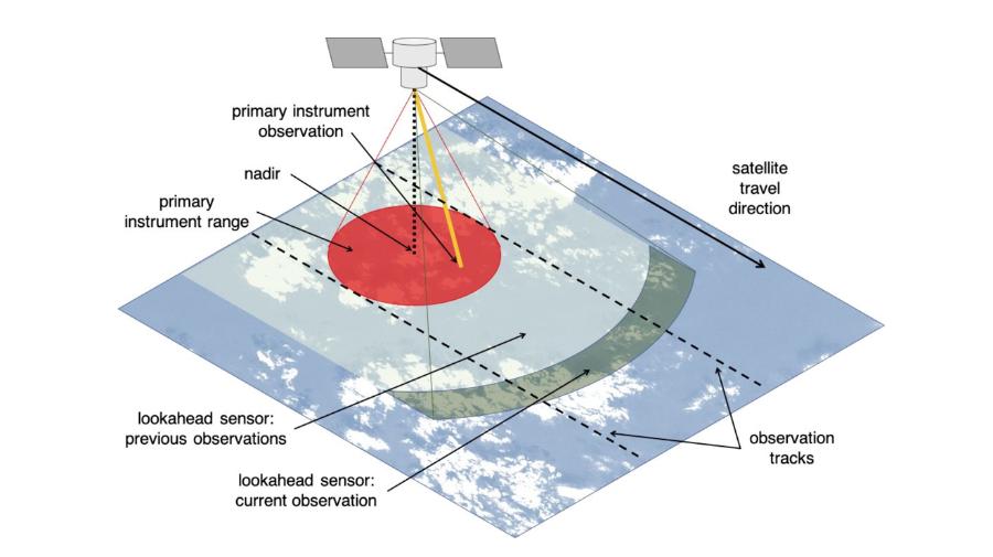
How Dynamic Targeting Works
The test took place aboard CogniSAT-6, a briefcase-sized CubeSat launched in March 2024. Built and operated by Open Cosmos with a payload developed by Irish space AI company Ubotica, this small but mighty satellite carries powerful edge computing capabilities.
Here’s how the system works:
- The satellite tilts forward 40-50 degrees to look ahead along its orbit, about 300 miles (500 kilometers) in advance
- Its optical sensor captures both visible and near-infrared images
- Onboard AI analyzes these images to identify clouds
- The Dynamic Targeting software decides which areas to photograph
- The satellite tilts back to point straight down (nadir)
- It captures images of only clear, cloud-free surface
All this happens within 60-90 seconds as the satellite travels at nearly 17,000 mph (7.5 kilometers per second).
The Brains Behind the Operation
At the heart of CogniSAT-6 is Ubotica’s CogniSAT-XE1 board, powered by an Intel Movidius Myriad 2 Vision Processing Unit (VPU). This specialized AI processor features:
- 12 vector cores for parallel processing
- Hardware acceleration for neural networks
- Power envelope under 5W
- PC/104 form factor for easy integration into CubeSats
- Support for TensorFlow, PyTorch, and Caffe frameworks
“This is a paradigm shift for Earth Observation,” notes Fintan Buckley, CEO of Ubotica. “The industry has long sought a model of live Earth intelligence, where insights are generated onboard satellite and instantly relayed to ground.”

More Than a Decade in Development
Dynamic Targeting didn’t appear overnight. The technology has been in development at JPL for over ten years, with initial trials conducted aboard the International Space Station in 2022. These tests used algorithms similar to those now flying on CogniSAT-6, proving the concept could work in space.
Steve Chien, a technical fellow in AI at JPL and principal investigator for the project, explains the core concept: “The idea is to make the spacecraft act more like a human: Instead of just seeing data, it’s thinking about what the data shows and how to respond. When a human sees a picture of trees burning, they understand it may indicate a forest fire, not just a collection of red and orange pixels.”
From Avoiding Clouds to Finding Fires
With cloud-avoidance capability now proven, the JPL team has ambitious plans for future tests:
- Hunting for storms and severe weather (targeting clouds instead of avoiding them)
- Searching for thermal anomalies like wildfires and volcanic eruptions
- Studying rare deep convective ice storms using specialized radar
- Testing “Federated Autonomous Measurement” where multiple satellites work together
The last concept is particularly exciting. Later in 2025, NASA plans to test a system where one satellite detects something interesting, then quickly communicates this information to other satellites trailing behind it. Those satellites can then reorient themselves to observe the same phenomenon, creating a coordinated response system in orbit.
Beyond Earth: Planetary Applications
The technology’s potential extends beyond our planet. Chien and his colleagues drew inspiration from earlier work with ESA’s Rosetta orbiter, which demonstrated the feasibility of autonomously detecting and imaging plumes from Comet 67P/Churyumov-Gerasimenko.
Similar approaches could be used to spot geysers on icy moons, track dust storms on Mars, or monitor other dynamic events throughout the solar system.
The Technology Package
CogniSAT-6’s hardware supports the complete AI workflow:
- Data acquisition from onboard cameras
- Image processing and analysis using neural networks
- Decision-making based on analysis results
- Communication of insights to ground stations
The satellite’s inter-satellite link capability enables it to transmit data quickly. In a demonstration over Khor Fakkan, UAE, the system identified ships and relayed this information via inter-satellite link, bypassing the need to wait for a ground station pass.
The Earth Observation Revolution
Traditional Earth observation satellites follow pre-programmed routines, capturing whatever happens to be below them, whether useful or not. Dynamic Targeting flips this model, allowing satellites to actively search for specific phenomena and make real-time decisions about what deserves attention.
This capability is particularly valuable for monitoring rapidly changing events like natural disasters. By the time a traditional satellite spots a wildfire and relays that information to Earth, hours or even days might pass. With Dynamic Targeting, satellites can detect such events immediately and autonomously decide to gather more data.
Real-World Applications
The potential applications for this technology are far-reaching:
- More efficient monitoring of natural disasters like wildfires, floods, and volcanic eruptions
- Better tracking of severe weather systems, including rare ice storms
- Improved maritime monitoring for ship traffic, illegal fishing, and oil spills
- Enhanced agricultural monitoring by focusing on areas without cloud cover
- More effective climate change research with higher-quality data sets
A Milestone in Space AI
The successful July 2025 test represents more than just a technical achievement – it marks a philosophical shift in how we approach Earth observation. Rather than passive collectors of data, satellites are becoming intelligent observers, making decisions that previously required human intervention.
As the technology continues to develop and more satellites adopt similar capabilities, we can expect faster, more targeted, and more useful information about our changing planet.