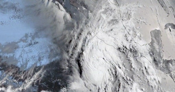
Bottom Line: Tropical Depression One-E strengthened into Tropical Storm Alvin on Wednesday afternoon, becoming the first named storm of 2025 in the Western Hemisphere’s Eastern Pacific basin. While the storm poses minimal direct threat to U.S. coastlines, it serves as an early indicator of warmer ocean conditions and atmospheric patterns that could fuel more significant tropical activity in both Pacific and Atlantic basins throughout the season.
Tropical Storm Alvin formed several hundred miles south of Mexico’s Pacific Coast on Wednesday, with the National Hurricane Center forecasting modest strengthening before the system encounters hostile environmental conditions. The system had maximum sustained winds of 40 mph as of Thursday morning, with some additional strengthening expected through Thursday night, and some of the storm’s outer rain bands reaching the Mexican states of Michoacán, Colima and Jalisco.
Unusual Early Formation Points to Warmer Ocean Conditions
The average date for the first tropical storm of the eastern Pacific season is June 10, according to the National Hurricane Center. If a storm forms soon, it would be well ahead of the historical pace — and much earlier than last year’s first storm. In 2024, Aletta didn’t form until July 4, marking the latest start to an eastern Pacific hurricane season in the satellite era.
The formation of Alvin reflects underlying ocean conditions that have created an environment conducive to tropical development. Climate scientists have identified the critical importance of warm sea surface temperatures in driving increasingly intense tropical cyclone activity. Sea surface temperatures of at least 26°C would favour the formation of tropical cyclones, and current conditions in the Eastern Pacific development region exceed this threshold.
ENSO-Neutral Conditions Set Stage for Active Season
ENSO-neutral is favored through The Northern Hemisphere summer 2025 (74% chance during June-August), with chances exceeding 50% through August-October 2025, according to NOAA’s Climate Prediction Center. The season is expected to be above normal – due to a confluence of factors, including continued ENSO-neutral conditions, warmer than average ocean temperatures, forecasts for weak wind shear.
The ENSO cycle-which alternates between El Niño (warmer Pacific waters) and La Niña (cooler Pacific waters) is now as of May 2025 in a neutral phase. This phase reduces wind shear in the Atlantic, creating favorable conditions for tropical storm development. The incidence of hurricanes is higher during the neutral phase (when neither El Niño nor La Niña are in effect) than during El Niño. This atmospheric setup allows tropical systems to develop with less interference from disruptive upper-level winds that would otherwise tear apart developing storms.
Technical Forecasting Advances for 2025 Season
The 2025 hurricane season brings several significant improvements to forecasting capabilities. NOAA’s Central Pacific Hurricane Center and National Hurricane Center are extending forecasts a day earlier on the sustained hurricane-force wind field (74 miles per hour) from 48 to 72 hours.
New this year, the Central Pacific Hurricane Center and National Hurricane Center will be able to issue potential tropical cyclone advisory products up to 72 hours before the anticipated arrival of storm surge or tropical-storm-force winds on land, giving communities more time to prepare. These expanded forecast timelines represent a crucial advancement for emergency management, providing coastal residents and officials with additional lead time to complete preparations and evacuations when necessary.
Mexico’s Seasonal Outlook Projects Above-Average Activity
On May 7, 2025, the Servicio Meteorológico Nacional (SMN) issued its first outlook for the Pacific hurricane season, forecasting an above average season with 16–20 named storms, 8–11 hurricanes, and 4–6 major hurricanes. This forecast aligns with above-average sea surface temperatures and the ENSO-neutral pattern, explaining why a system formed in late May rather than the typical early June timeframe.
Based on this year’s list of storm names, Alvin will be followed by Barbara, Cosme and Dalila. The early formation pattern suggests the season could maintain elevated activity levels through the peak months.
Similar Posts
Central American Gyre May Fuel Caribbean Development
The storm-sparking pattern over the eastern Pacific will probably move into the Atlantic over the next few weeks, bringing the first opportunity for a tropical storm or hurricane in the Caribbean Sea or Gulf of Mexico. An eastward-moving pulse of rain and cloud, called the Madden-Julian Oscillation, will migrate into the Atlantic Ocean during mid-June.
The Central American Gyre represents a significant atmospheric feature that can simultaneously support tropical development in both the Eastern Pacific and western Caribbean regions. CAGs can also help produce tropical cyclones in the eastern Pacific and western Atlantic simultaneously. In May and June 2020, a CAG contributed to the formation of Tropical storms Amanda and Cristobal in the eastern Pacific and Gulf of Mexico.
The Central American gyre (CAG) is a broad and seasonal area of low pressure that occurs over the eastern Pacific Ocean and western Caribbean Sea. It primarily develops annually during the region’s rainy season between May and November, and most commonly occurs during late spring (May–June) and early fall (October–November).
Atlantic Season Poised for Above-Normal Activity
The agency is forecasting a range of 13 to 19 total named storms (winds of 39 mph or higher). Of those, 6-10 are forecast to become hurricanes (winds of 74 mph or higher), including 3-5 major hurricanes (category 3, 4 or 5; with winds of 111 mph or higher), according to NOAA’s seasonal forecast.
The high activity era continues in the Atlantic Basin, featuring high-heat content in the ocean and reduced trade winds. The higher-heat content provides more energy to fuel storm development, while weaker winds allow the storms to develop without disruption.
The combination of ENSO-neutral conditions, warm Atlantic sea surface temperatures, and reduced wind shear creates an environment similar to previous active seasons. Research into extreme weather patterns and intensifying storm systems continues to reveal how changing climate conditions affect tropical cyclone development patterns. Historical analysis shows that major active seasons often occur during ENSO-neutral conditions, providing the atmospheric stability needed for sustained tropical development.
Immediate Impacts and Future Tracking
As the storm strengthens offshore through Friday, it will have some effects across Mexico. The moist pattern associated with the system will bring locally heavy showers and thunderstorms to inland parts of the country, beneficial in areas that have been unusually dry during recent months.

As it moves northward Saturday, the storm will probably ingest dry air and encounter harsher winds and cooler seas, causing it to weaken. Some rain from the storm could reach southern Baja California Sur on Saturday and/or Sunday, including the area around Cabo San Lucas, Mexico.
Remnant moisture from future Alvin in combination with an upper low could also ignite an uptick in thunderstorms over the Southwest U.S. this weekend, especially by Sunday. This moisture transport pattern occasionally brings beneficial rainfall to drought-affected regions of the southwestern United States.
The Bottom Line: Tropical Storm Alvin’s early formation in the Eastern Pacific demonstrates the warm ocean conditions and favorable atmospheric patterns that are expected to drive above-normal tropical activity in the Atlantic basin during 2025, while the Eastern Pacific is forecast for near-average activity by NOAA and above-average by Mexico’s weather service. While Alvin itself poses limited direct threats to major population centers, its development serves as the opening chapter of what forecasters predict will be an active and potentially dangerous hurricane season across multiple ocean basins