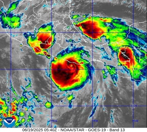
Hurricane Erick has rapidly intensified into a Category 4 storm with sustained winds of 145 mph (230 km/h) as it approaches Mexico’s Pacific coast. The powerful storm is expected to make landfall early Thursday morning, June 19, 2025, threatening western Oaxaca or eastern Guerrero with potentially devastating impacts.
The U.S. National Hurricane Center (NHC) warns of “devastating wind damage” where the core moves onshore. The storm is also expected to bring “life-threatening flooding and mudslides” from heavy rainfall of 8 to 12 inches, with isolated totals reaching up to 16 inches in Oaxaca and Guerrero.
What makes Erick particularly concerning is how quickly it strengthened. The hurricane doubled in power in less than a day, demonstrating what meteorologists call “rapid intensification” – when a storm’s wind speed increases by at least 35 mph within 24 hours.
Similar Posts:
“This type of rapid intensification has become more common in a warmer climate,” noted the National Hurricane Center, which recorded 34 such incidents last year, about twice the average number.
Mexican President Claudia Sheinbaum has urged residents in affected areas to “stay indoors, and not go out.” For those in low-lying areas, she advised seeking shelter immediately: “If you are in low-lying areas, near rivers, near waterways, it is best for you to go to shelters.”
Authorities have taken extensive precautions:
- Suspended all movement in Acapulco and other beach communities
- Closed schools in Guerrero state for a second day
- Shut down Acapulco’s port
- Prepared 582 shelters for evacuees
- Mobilized over 18,000 first responders across Chiapas, Guerrero, and Oaxaca
The situation is especially worrying for Acapulco, which is still recovering from Hurricane Otis. That Category 5 storm devastated the resort city in October 2023, killing at least 50 people. Many were caught unprepared when Otis also rapidly intensified before landfall.

“Erick is no Otis,” explained University at Albany atmospheric scientist Kristen Corbosiero, noting that Erick is an early-season storm while Otis hit in October when deeper, warmer waters helped fuel its extreme strength. Nevertheless, Erick has found ideal conditions to power up, with an extremely moist atmosphere, absence of dry air, and a well-formed eye.
Hurricane Erick is the earliest fifth-named storm in the Eastern Pacific since July 9, 1956, highlighting an unusually active start to the 2025 hurricane season. The Eastern Pacific hurricane season typically averages 15 named storms.
A hurricane warning covers a 300-mile stretch of Pacific coastline from Acapulco to Puerto Ángel. People in mountainous areas face additional risks from mudslides due to the heavy rainfall.