Tropical Cyclone Maila | Category 3 Tracking Toward Far North Queensland – April 2026
Active System
Another Cyclone Heading for Far North Queensland
Severe Tropical Cyclone Maila — Category 3 — is tracking southwest from the Solomon Sea. It is the 11th named system of the 2025–26 Australian cyclone season, arriving just weeks after Cyclone Narelle.
165 km/h
Sustained winds
185 km/h
Peak gusts
Cat 3
BoM Classification
1,265 km
NE of Cairns
Source: Bureau of Meteorology, April 5, 2026
As of Monday, 7 April 2026, Severe Tropical Cyclone Maila is positioned in the Solomon Sea, approximately 1,265 km northeast of Cairns. The system was named Saturday night and is the first cyclone named by the Tropical Cyclone Warning Centre (TCWC) Port Moresby since Cyclone Guba in 2007. Bureau of Meteorology senior meteorologist Badwen Gilbert stated there is “increasing confidence” Maila will track toward Far North Queensland by the weekend. Communities still recovering from Cyclone Narelle’s damage in March 2026 face renewed risks as ground saturation levels remain elevated across affected regions. Always check the latest alerts directly from the Bureau of Meteorology.
Three Possible Paths for Cyclone Maila
Select a forecast scenario to understand what each track means for your region. All scenarios are based on BoM guidance as of April 6, 2026.
High Impact
Direct Coastal Landfall — Far North Queensland
If the strengthening eastern ridge steers Maila without disruption, the system could make landfall directly on the FNQ coast, bringing sustained winds of up to 130 km/h along the coast and rainfall totals of 200–400 mm over 24–48 hours in localised zones.
Flood Risk
Who Needs to Watch
Residents of Cairns, Cape Tribulation, Port Stewart, the Cassowary Coast, and the Daintree are within the primary risk zone. Ground already saturated from Narelle increases the probability of flash flooding and river rises.
Moderate Impact
Crosses Cape York Peninsula and Weakens
The system crosses the Cape York Peninsula and weakens over land. Rainfall and wind impacts are still significant inland, particularly for communities along the Cape York corridor. Flooding risk remains for low-lying river systems.
Gulf Threat Possible
Potential Re-intensification in the Gulf
After crossing Cape York, Weatherzone notes the system “could weaken over land and then reintensify in the Gulf of Carpentaria, before impacting the eastern Top End early next week.” Communities in the NT should monitor NT Emergency Services.
Lower Coastal Impact
Weakens Before Reaching the Coast
Interaction with the Papuan Peninsula could cause temporary weakening before Maila reaches the Gulf of Carpentaria. Coastal impacts for FNQ would be reduced, though heavy rainfall bands can still extend well ahead of a weakened system.
Top End Watch
Northern Territory Communities on Notice
A re-developed system in the Gulf of Carpentaria could track westward, impacting the eastern Top End. Katherine, which faced its second major flood in three weeks during Narelle, is flagged as a watch zone by the Katherine Town Council.
Wind Speed in Context
How Maila’s winds compare to real-world thresholds — figures from the Bureau of Meteorology and Australian tropical cyclone scale.
Maila — Sustained
165 km/h
Maila — Peak Gusts
185 km/h
Narelle — Pilbara Gusts
250 km/h
Cat 3 Threshold (BoM)
~116 km/h
Landfall Estimate (FNQ)
130 km/h
What Cyclone Narelle Left Behind — March 2026
Understanding the damage already on the ground helps explain why Maila is being treated seriously even at this distance.
Mid-March 2026 — Formation
Narelle Forms Near the Solomons
Tropical Cyclone Narelle formed near the Solomon Islands and began a 5,700 km journey southwestward, eventually traversing three Australian states and territories — Queensland, the Northern Territory, and Western Australia.
Mid–Late March — Queensland & NT
Evacuations, Flooding and ADF Deployment
Hundreds were evacuated from Port Stewart (QLD) and Numbulwar (NT). Schools were closed, flights cancelled, and emergency packs distributed. The Daly River reached major flood levels for several days. Katherine faced its second major flood in three weeks, prompting Australian Defence Force emergency assistance and recovery operations.
Late March — Western Australia
Category 3 Landfall Between Coral Bay and Cape Cuvier
Narelle swept through the remote Pilbara region bordering Ningaloo Reef with wind gusts of 250 km/h and 350 mm of rainfall. Exmouth residents were left without power and water. Chevron and Woodside gas production facilities paused operations due to infrastructure damage.
30 March — NT Recovery
Katherine Hospital Staged Reopening
Katherine Hospital began a staged reopening from March 30. The NT Government activated Immediate Relief Payments for residents of Katherine and Wugularr (Beswick) — eligible adults: $611, children: $309 each, capped at $1,537 per family. Details are available through the Secure NT recovery portal.
Early April 2026 — QLD Roads
Road Reconstruction Under DRFA Funding
The Queensland Department of Transport and Main Roads is managing geotechnical slope stabilisation on Captain Cook Highway and Palmerston Highway. Betterment works on Gillies Range Road and Kuranda Range Road are funded through the Queensland Reconstruction Authority via Disaster Recovery Funding Arrangements.
Post-Narelle: Key Recovery Information
💊
Melioidosis Health Warning
Local health authorities in the Top End have issued warnings about Melioidosis, a soil-borne disease that spikes after heavy rain. Wear waterproof footwear and gloves while cleaning up. Avoid high-pressure hosing of soil. See NT Health for guidance.
💰
Financial Relief — NT
Eligible Katherine and Wugularr residents can access NT Government Immediate Relief Payments: $611 per adult, $309 per child, up to $1,537 per family. Apply via the Secure NT portal.
🛣️
Queensland Road Updates
Slope stabilisation is underway on Captain Cook Highway, Palmerston Highway, Gillies Range Road, and Kuranda Range Road. Check live conditions via Queensland TMR before travel.
If near floodplains — move valuables to upper floors
0 of 8 complete
Common Questions About Cyclone Maila
Answers based on Bureau of Meteorology data and NT/QLD government advisories as of April 6, 2026.
Maila is currently a Category 3 system on the Australian tropical cyclone scale, with sustained winds of 165 km/h near the centre and peak gusts of 185 km/h. Track the latest data directly on the Bureau of Meteorology cyclone page.
BoM has stated there is “increasing confidence” Maila will track toward Far North Queensland by the weekend. However, the exact track and intensity at landfall remain uncertain. The forecast cone covers scenarios from a direct FNQ hit to a Cape York crossing with Gulf reintensification. Monitor BoM Queensland for updates every six hours.
A Cyclone Watch means a cyclone could affect your area within 48 hours — preparation time. A Cyclone Warning means a cyclone is expected to affect your area within 24 hours — take immediate action. Details on both levels are published by the Bureau of Meteorology.
The 2025–26 Australian cyclone season runs until the end of April 2026. Maila is the 11th named system this season — a notably active tally. Forecasters note that sea surface temperatures in the Coral Sea and Solomon Sea have remained above the 26.5°C threshold required for tropical cyclone formation, which has been supporting intensification. More on climate and extreme weather coverage at Karmactive.
Forecasters say it is too early to determine whether Maila will impact Western Australia. Top End communities are being reminded to check for updates as a weakened or redeveloped system moving west could still bring heavy downpours. Visit WA Emergency for current advisories.
Tropical Cyclone Maila’s position, wind intensity, and projected track toward Far North Queensland were covered, along with three possible forecast scenarios based on Bureau of Meteorology guidance. The damage and recovery data from Cyclone Narelle — spanning Queensland, the Northern Territory, and Western Australia — were outlined, together with NT Government financial relief details, public health warnings related to Melioidosis, and ongoing Queensland road reconstruction works. The 2025–26 cyclone season’s activity and emergency preparedness steps were also addressed. For the latest updates visit the Bureau of Meteorology or Queensland Disaster Management. Further extreme weather and climate coverage is available at Karmactive.
Australia Cuts Petrol Prices by 32¢ a Litre | KarmActive KarmActive · Fuel & Energy · Australia 2026 Fuel Policy Petrol Drops 32¢ a Litre — But the Numbers Behind the Relief
Australia Braces for Catastrophic Flooding: Tropical Lows Unleash Record Rainfall Across Queensland and NT Australia Braces for Catastrophic Flooding: Tropical Lows Unleash Record Rainfall Across Queensland and NT Two tropical low-pressure systems
Australia’s Best Beaches 2026: Bate Bay Ranked No.1 by Tourism Australia Wanda’s sand dunes stretch toward the Kurnell Peninsula — Bate Bay, NSW. Photo: Adam J.W.C., Wikimedia Commons (CC BY-SA 3.0) 🏈
AusAlert 2026: Australia’s National Emergency Warning System — Tested on 23 Million Phones Australia · Emergency Alert · 2026 AusAlertIs Coming Australia’s $132 million national emergency warning system launches in October 2026
Blood Moon March 2026 — Total Lunar Eclipse Australia 🔴 Total Lunar Eclipse · March 2026 · Australia Australia’s Sky TurnsBlood Red on March 2 The first total lunar eclipse of 2026
Sydney Shark Incidents: Three Events in 26 Hours Temporary beach closure and shark sighting warning signs stand along Dee Why Beach after multiple shark incidents were reported across Sydney’s coastline within a
🚨 ACTIVE WARNINGS – Multiple bushfires across NSW and Tasmania – December 5, 2025 EMERGENCY UPDATES Australia Bushfire Emergency: Real-Time Tracking Active bushfires continue across eastern Australia as severe heatwave conditions drive
Fatal Shark Attack at Crowdy Bay NSW – Complete Report Kylies Beach in Crowdy Bay National Park, NSW Mid North Coast, where the fatal shark attack occurred. Photo: Representative image Breaking News
Asbestos in Children’s Sand Recall: Facts, Health Risks & Action Steps Health Alert November 2025 Asbestos Found in Children’s Play Sand: A National Recall Explained Schools across Australia and New Zealand closed
Bureau of Meteorology Website Cost: Hidden Expenses Revealed Bureau of Meteorology weather radar at Berrimah, Northern Territory — the critical infrastructure that powers Australia’s national weather forecasts. The radar network underpins the
Weather & Safety Thousands without power in Queensland as Victoria experiences ‘terrifying’ winds after year’s wettest day About 26,000 households were without power in South-East Queensland on Monday morning after severe thunderstorms,
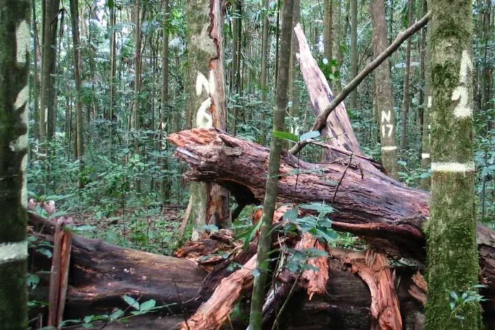
Environment 📅 Oct 26, 2025 ⏱️ 3–4 min interactive Queensland’s Tropical Rainforests Now Release More Carbon Than They Absorb A long-term record from north‑eastern Australia reports a shift in above‑ground biomass balance:
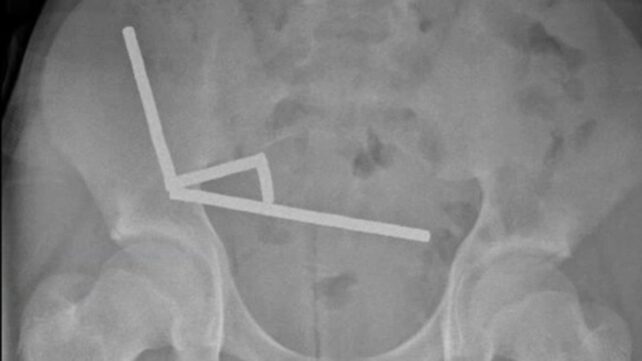
Health & Safety New Zealand Teen Loses Part of Bowel After Swallowing Powerful Magnets A 13‑year‑old was admitted to Tauranga Hospital after four days of abdominal pain. An X‑ray showed four linear
EV Launch Tracker 2026 Mazda 6e Electric Sedan Confirmed for Australia Rear‑wheel‑drive electric sedan slated for Q2 2026 Australian launch with a sub-$55K target, a 78 kWh LFP battery, claimed 500 km WLTP range,