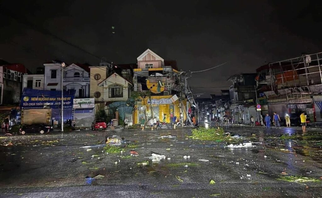
Typhoon Kajiki struck Vietnam’s central coast Monday, August 25, causing widespread blackouts across multiple provinces with at least 331 power poles downed and triggering widespread flooding in Hanoi—just days before the capital’s National Day celebrations.
The storm made landfall with sustained winds of approximately 117-130 kph (72-81 mph) according to Vietnam’s National Center for Hydro-Meteorological Forecasting (NCHMF), before weakening into a tropical depression as it moved toward Laos.
Human Toll and Immediate Impact
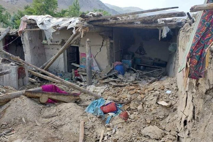
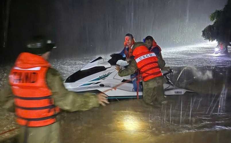
Official reports confirm three deaths with 10-13 injuries reported in government and state media updates. Emergency crews have evacuated more than 44,000 people from central regions, though government plans had called for relocating nearly 587,000 residents from vulnerable areas.
Forecasters warned some areas could see 200-400 mm of rain, with isolated totals above 600 mm, and up to 150 mm in six hours, creating dangerous flash flood conditions across multiple regions.
The destruction spans:
- Nearly 7,000 homes damaged
- Over 28,000 hectares of rice fields submerged
- 18,000 trees toppled
- 331 power poles downed
Hanoi Underwater
In the capital, residents pushed motorbikes through knee-deep water as streets turned to rivers. Floodwaters reached nearly 1 meter in places (e.g., National Highway 6), stalling cars and motorbikes. The flooding has complicated preparations for Vietnam’s National Day parade.
According to NCHMF alerts issued on August 26: “Convective clouds are forming and causing rain over Ha Dong, Kien Hung, and Phu Luong districts. These storm clouds are developing and moving north and northwest, expected to expand over the next 3 hours to affect nearby areas including Dai Mo, Tay Mo, Duong Noi, Thanh Liet, Thanh Xuan, Yen Hoa, Cau Giay, and Tu Liem districts.” The agency has issued a Level 1 risk warning for thunderstorms, lightning, and strong gusts across Hanoi’s inner districts.
Airports in central provinces (including Tho Xuan in Thanh Hoa and Dong Hoi in Quang Binh) were closed, with flights throughout the region disrupted.
Military and Humanitarian Response
Vietnam has mobilized 16,500 soldiers and 107,000 paramilitary personnel to assist with rescue and recovery operations.
Authorities and volunteers are focused on providing emergency assistance to affected areas, with relief efforts targeting the most vulnerable populations including elderly residents and children.
Government and relief agencies are working to address priority needs including shelter repair, food assistance, and power restoration in the hardest-hit regions.
More posts
Health Concerns Rising
Health officials note that post-flood periods typically increase the risk of waterborne and vector-borne diseases such as dengue fever and diarrheal outbreaks. Priority measures include hygiene kits, safe water provision, and proper sanitation to prevent disease spread in affected communities.
Regional Impact and Ongoing Threats
As Kajiki’s remnants move westward, Laos has issued nationwide alerts for heavy rain and strong winds. Thailand’s Meteorological Department forecasts heavy rain from August 25-27, with warnings of potential landslides in mountainous areas.
The NCHMF has issued a new alert about a low-pressure system currently operating east of the Philippines (15.5-16.5°N; 123.5-124.5°E as of 13:00 on August 26). Within 24-36 hours, this system is expected to move west-northwest at 15-20 km/h, entering the northern East Sea with potential to strengthen into a tropical depression by August 27-28.
Additionally, NCHMF has issued strong wind and high wave warnings for maritime areas, with southwestern winds of Force 6, gusting to Force 7-8 and waves of 2.0-3.5 meters expected in waters from Lam Dong to Ho Chi Minh City and northern parts of the South China Sea.

Flood Warnings for Multiple River Basins
The NCHMF has issued urgent flood warnings for several major river systems:
“Flood levels on the Thao River (Lao Cai), Luc Nam River (Bac Ninh), Hoang Long River (Ninh Binh), and Ma River system (Thanh Hoa) are rising, while upstream Cả River (Nghe An) floods are receding,” the agency reports.
In the next 6-12 hours, floods on the Thao River and lower Ma River are expected to rise rapidly to Alert Levels 2-3. Within 12-24 hours, these rivers may exceed Alert Level 3 and remain high. The agency has issued Level 2-3 risk warnings for flash floods and landslides across Lao Cai, Phu Tho, Bac Ninh, Ninh Binh, Thanh Hoa, and Nghe An provinces.
Heavy rainfall warnings have been issued for midland and delta regions of Northern Vietnam, Son La, Lao Cai, and Thanh Hoa, with expected rainfall of 50-100mm through August 27, with some localities potentially receiving over 200mm. Particularly intense rainfall exceeding 100mm in 3 hours is possible in some areas.
Environmental Context
Vietnam is hit by several tropical storms and typhoons each year, with high exposure along its long coastline, and climate researchers note concerning trends.
A 2024 study published by Garner et al. in Climate and Atmospheric Science finds cyclones in Southeast Asia forming closer to land, intensifying more rapidly, and lingering longer due to warming seas. Coastal cities like Hai Phong and Bangkok face increased risk under these conditions.
This disaster compounds an already difficult year—Vietnam’s Ministry of Agriculture confirmed over 100 people dead or missing due to natural disasters between January and July 2025.
Typhoon Yagi, which struck the region in September 2024, killed more than 500 people across Southeast Asia, demonstrating the growing severity of storms affecting the region.
Recovery Efforts Underway
Recovery operations continue as officials monitor forecasts for additional rainfall. Hanoi and central Vietnam provinces are currently focused on power restoration, clearing roads, and providing shelter for displaced residents.
Authorities are prioritizing assistance in hard-hit provinces including Nghe An, Ha Tinh, and Thanh Hoa, where many communities face extended periods without electricity.
The death toll stands at three, with damage assessments ongoing as floodwaters recede in some areas while continuing to rise in others.
The NCHMF continues to issue real-time warnings for flash floods and landslides across multiple provinces, with detailed risk maps available at http://luquetsatlo.nchmf.gov.vn.