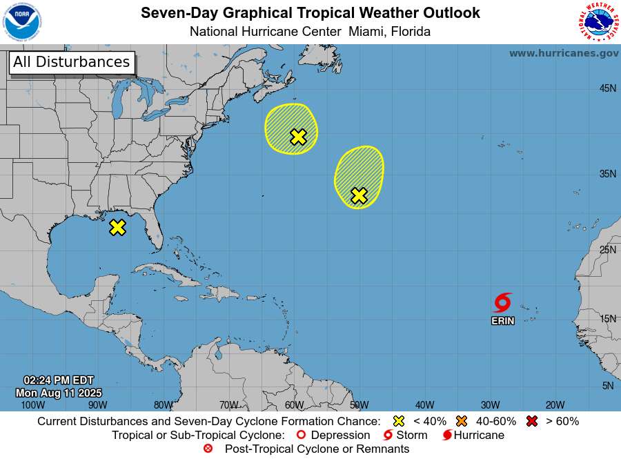
A tropical system known as Invest 97L is showing strong signs of becoming the Atlantic’s first hurricane of 2025, with forecasters giving it a 90% chance of development within the next seven days.
The National Hurricane Center reports that “showers and thunderstorms continue to show signs of organization” around a well-defined low pressure area near the northwestern Cabo Verde Islands. The system is expected to become a tropical depression within the next day or so as it moves westward across the Atlantic.
“A tropical system is expected to form soon in the Atlantic…even as early as tonight into Monday,” said Meteorologist Matt Devitt. “This system does have the potential to become the first hurricane of the 2025 Atlantic Season.”
Currently labeled Invest 97L, this designation allows the Hurricane Center to run specialized computer models to better track the system’s potential development and path. If it strengthens into a tropical storm, it would be named Erin, the fifth named storm of the 2025 season.
The timing is significant as August 11th marks the average date for the first hurricane of the Atlantic season. While four named storms have already formed this year – Andrea, Barry, Chantal, and Dexter – none developed into hurricanes.
Similar Posts
Weather experts are watching this system closely because conditions ahead of it appear particularly favorable for strengthening. Sea surface temperatures across the central and western Atlantic are in the mid-to-high 80s, with some areas near 90 degrees – conditions highly favorable for intensification.
The system’s future path remains uncertain, though most computer models currently suggest a general westward movement initially, followed by a northward turn later next week. As of Sunday evening, both the American GFS and European ECMWF models curve the storm north in the Atlantic before any potential Florida landfall. However, previous model runs have brought the storm closer to the U.S. coast.
According to WeatherTiger meteorologist Ryan Truchelut, “We know well hurricane seasons can be nowhere to be found, then suddenly impossible to avoid. While there is hope the active peak months of hurricane season may not translate into another awful year in human terms, the reality is that U.S. hurricane impacts are likely and to be expected over the next few months.”
This activity comes as no surprise to forecasters. NOAA predicted a 60% chance of above-normal activity for the 2025 Atlantic hurricane season, and forecasts called for up to 18 named systems this year, including between five and nine hurricanes.
Looking ahead, hurricane experts warn that the end of August looks to keep forecasters busy, with two or three other disturbances forecast to move off Africa behind this one. This increased activity aligns with typical patterns, as the peak of hurricane season is September 10, with most activity happening between mid-August and mid-October
For coastal residents, now is the time to review hurricane preparation plans, as Invest 97L represents the beginning of what could be an active period in the 2025 hurricane season.
